The Mapping Militants Project (MMP) identifies patterns in the evolution of militant organizations in specified conflict theatres and provides representations of changing relationships among groups. Relationships are traced in interactive timeline-diagrams or “maps,” which provide visual representations of how inter-group relationships such as rivalries and alliances change over time. The maps are linked to group profiles, which compile open-source news and data on militant organizations to provide a comprehensive, fully cited report on each group.
Welcome
MMP by Numbers

112 Full Profiles of Militant Organizations

15 Regional "Maps"

712 inter-group relationships
Recent updates and new profiles
Communist Party of the Philippines - New People's Army
Profile Last Updated:
August 1, 2018
The Communist Party of the Philippines–New People’s Army (CPP-NPA) seeks to overthrow the Philippine government in favor of a new state led by the working class and to expel U.S. influence from the Philippines.
Taliban
Profile Last Updated:
November 1, 2022
The Afghan Taliban is a Sunni Islamist militant organization that emerged in 1994 during the Afghan civil war to establish a Shariah-governed Afghan state. The Taliban achieved this goal in 1996 and ruled Afghanistan until late 2001. After the attacks of 9/11, an American-led invasion removed the Taliban regime from power.
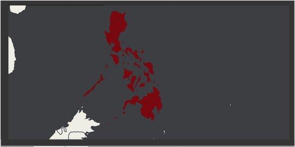
Philippines
This map displays the relationships between the Communist/Socialist revolutionary groups and the Islamic revolutionary groups in the Philippines.