|
|
The NSTB WAAS:
|
In support of the FAA's Wide Area Augmentation System (WAAS) for GPS the Wide Area Differential GPS Laboratory at Stanford University has spear-headed a technical research effort to demonstrate the wide-area differential concept in practice. A full realization of WAAS will provide aircraft guidance throughout the en route, terminal, non-precision, and precision approach phases of flight. The most demanding phase is precision approach where vertical accuracy of ones of meters is combined with safety of life integrity requirements. As part of its on-going research cooperation with the FAA, Stanford has designed, built, and flight tested a real-time WAAS implementation.
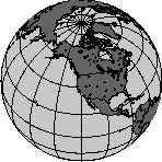
The Wide Area Differential GPS Laboratory at Stanford University is connected in real-time to the network of dual-frequency GPS reference stations shown in the rotating figure above. This network, called the National Satellite Test Bed (NSTB), is sponsored by the FAA Satellite Navigation Program Office and maintained by the FAA Technical Center in Atlantic City, NJ. The GPS observables (pseudo-range and carrier phase on both L1 and L2) from each receiver in the network are sent as multi-cast User Datagram Protocol (UDP) packets via ethernet at 1Hz to our central processing facility located on the Stanford campus.
The fundamental concept of wide-area differential GPS is the categorization of error sources in the GPS observables. By constructing a model for each error source the system creates a so called vector correction. This is the distinction between wide-area and local-area differential corrections. Local-area augmentation systems transmit a scalar correction from the reference station to the user for each pseudo-range measurement. In contrast, wide-area systems transmit the error models to the user which are then recombined to form a correction for each pseudo-range measurement. The benefit of the vector correction is its improved ability to capture the spatial decorrelation of the error sources.
We have developed models for four separate GPS error sources: satellite clock, satellite ephemeris, ionospheric delay, and local errors (tropospheric delay, multipath, receiver noise and hardware bias). Analytic models are used to calibrate out the majority of the local errors in both the user and reference station observations. Models for the first three errors sources are constructed as real-time estimators which take as input the 1Hz stream of reference station observations. These measurements are then inverted with state space filters to form time dependent predictors of the GPS error terms over continental scales. The state space models are then packaged according to the RTCA WAAS Minimum Operational Performance Standards (MOPS) format into a 250 bit message stream suitable for broadcast transmission to GPS users.
Stanford's central processing facility is called a master station (TMS) and is hosted on a Digital Equipment Corporation AlphaServer 4100. The TMS is responsible for filtering all the GPS observables coming from the reference receivers, estimating the error model states, formatting the state estimates into a WAAS message stream, and displaying information to the operator. Figure 1 is a screen capture of the real-time TMS process depicting the status of the NSTB network at a single epoch on 29 March 1998. This, and in fact all, the displays are updated every second in operation to reflect the current state of the TMS.

Figure 1
Colored squares represent NSTB reference stations (TRSs). Filtered measurements from the blue (active) TRSs are used as input to the state estimators. The gold (passive) TRSs' measurements are being used as independent ``monitors'' to test the resulting pseudo-range corrections. The red squares indicate TRSs from which no GPS observations are received due to maintenance or communications outage.
The nominal separation of the TRSs is between 500 and 1000(km) with isolated clusters in Alaska and Hawaii. All TRSs house at least one dual-frequency survey grade receiver connected to a rubidium oscillator, a meteorological sensor, a processor, and network hardware for ethernet data transmission. In some TRSs there are two or even three receiver/oscillator combinations to explore the benefits of measurement redundancy.
Additional information on the satellite constellation can be rendered in real-time. Figure 2 shows the ground track of all the GPS space vehicles (SVs) based on the current almanac along with the footprint of the INMARSAT AOR-W and POR geosynchronous communication satellites. These latter two are used as the datalink for the WAAS differential corrections. As well, the two GEOs provide additional ranging sources since the broadcast channel is intentionally L1. The day/night terminator is indicated by the light to dark shading transition and the ground track of the eclipse region is also shown as the dark ellipse over eastern Africa.

Figure 2
Each SV ground track represents 2 hours ahead and behind the current epoch. The colors on the ground track indicate the predicted number of TRSs which should be monitoring that SV (legend is on righ). The colored circle indicates the current position and the actual number of TRSs tracking that SV.
The TMS displays tabular information updated in real-time. The primary information at the TMS is the current GPS week, time of week, UT hour, epoch (# of seconds the real-time process has been running), and the last ten WAAS format message types sent over the broadcast channel to the user. This information as seen in Figures 3-5 is displayed as a header running across each of the table displays. Of particular interest is the string of ten message types, where the first number (blue 24) indicates this epoch's outgoing message and the sixth number (magenta 63) is the most recent message at the user's receiver.
The unique information shown in the screen capture of Figure 3 is a line item for each receiver in the NSTB network. A receiver is designated by the two character name and unique ID number in the left two columns of the main table. Following each ID are the PRN numbers of the satellites (SVs) in view of the TRS with a 5° elevation mask, the local (E)ast, (N)orth, (U)p position error in meters with respect to surveyed antenna locations, local (T)emperature in centigrade, (P)ressure in millibars, relative (H)umidity in %, and lastly the L1/L2 hardware bias (IFB) calibration estimate in meters. Again each of these quantities is updated at 1Hz.

Figure 3
The color coding of each line in Figure 3 distinguishes active, passive, and incommunicado stations. Colored TRS entries correspond to passive monitors (gold in Figure 1) with the legend on the right indicating the number of SVs in local view currently corrected. The E/N/U columns report the error in the WAAS corrected navigation solution. The white receiver entries correspond to active stations (blue in Figure 1) and here the E/N/U columns reflect the error in the Standard Position Service GPS navigation solution. As you've probably guessed the red entries correspond to stations where no GPS observables were received during the epoch (red in Figure 1).
The second table, that shown in Figure 4, describes the satellite constellation in view of the entire TRS network. Each unique PRN code receives an entry for its current Issue of Data Ephemeris (IODE) which is needed for synchronizing the corrections the user's local constellation. The remaining columns contain TMS derived information from the state filters including the number of TRSs viewing the SV, the estimated ephemeris error components, dX, dY, dZ (m) in WGS-84 coordinates with respect to broadcast, the estimated clock error dB (m), the User Differential Range Error (m) which is best estimate of the one sigma confidence interval of the combined ephemeris/clock correction, the GPS health bit, the WAAS health bit (DNU), the Time of Ephemeris (seconds of week) corresponding to the IODE, and finally the satellite L1/L2 hardware bias (Tgd) which is the counterpart to the receiver IFB. The (dX,dY,dZ,dB) entries summarize the clock and ephemeris error models.
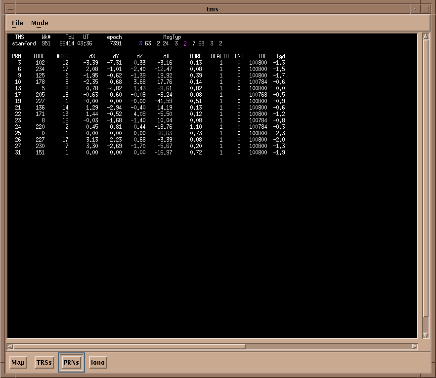
Figure 4
The conventional WAAS implementation models the ionosphere as a thin shell surrounding the earth, which discretized into a rectangular grid in latitude and longitude. The equivalent vertical delay induced by the ionosphere on a pseudo-range measurement is estimated at each grid point. The confidence interval, or Grid Ionosphere Vertical Error (GIVE), is also generated for each estimate. Figure 5 is a screen capture of the TMS display showing grid ionospheric estimates made from the dual frequency receiver measurements. The columns refer respectively to the grid point index, IGP, the latitude and longitude of the grid point, LAT/LON in degrees, the vertical delay, Iv in meters, and the confidence interval, GIVE in meters. The Iv and GIVE entries summarize the ionospheric error model.
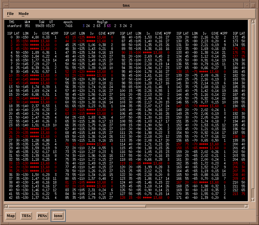
Figure 5
The TMS can be configured to treat any reference receiver as passive. The WAAS message stream generated by the active reference network is then applied with latency to observations from passive monitors in exactly the same manner as an aircraft on precision approach. The navigation solution is then computed from the differentially corrected pseudo-range measurements yielding a WAAS position solution.
Individual TRS plots are available in real-time for diagnosis and visualization. It is often convenient to track the azimuth/elevation of SV constellation in view as a skyplot. The screen capture in Figure 6 shows the SV az/el plot at Columbus, NE as observed over about three hours.

Figure 6
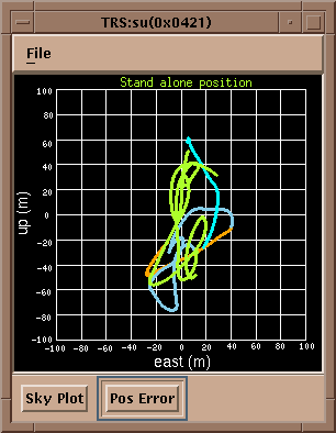
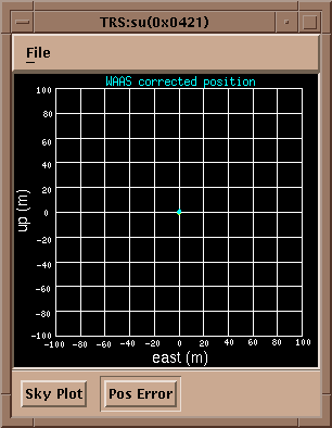
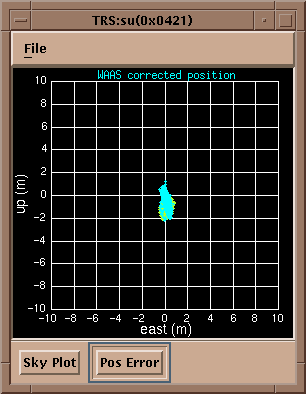
We also render, in real-time, the GPS Standard Positioning Service (uncorrected) or WAAS corrected navigation error as a scatter plot. The resulting plots track over time the ENU entries rolling through the TRS table described in Figure 3 above. The left plot in Figure 8 shows the SPS position error in the East and Vertical dimensions at Columbus. In the middle is the scatter plot for the WAAS position error at Stanford again in the East and Vertical. The right scatter plot also shows the WAAS corrected position error but now on a +/-10m scale, whereas the two on the left have scales of +/- 100m. The information in these plots was collected in real-time over a little more than two hours on 29 March.
|
|
|
|
Figure 8
While these screen captures from our implementation of a WAAS architecture are interesting, the power of this test bed is best demonstrated by our development and application of system metrics. These metrics are appropriate for quantifying safety of life navigation performance of models designed to correct the four categories of GPS errors which began our discussion.
As mentioned above, the clock, ephemeris, and ionospheric models are packaged into the WAAS MOPS format standardized by the RTCA. This message stream may then be broadcast through a geosynchronous satellite link to GPS users. Typically in research efforts such as that at Stanford, the correction is only broadcast on VHF data links for real-time flight tests in order to save communication costs.
In fact we maintain an active flight test program for not only wide-area GPS testing but also local-area, attitude, flight guidance display, and integrated GPS-inertial navigation research. Initially the flight platform was hosted on a Piper Dakota. More recently the platform was upgraded to a twin-engine airplane, a Beechcraft Queenair and then a Cessna Caravan. In the first two cases, the aircraft was outfitted with a VHF data link, multiple GPS antennas, and interchangeable navigation payloads. Since the WAAS messages are now continually broadcast by POR, a geo capable WAAS receiver is now used. Currently tests (2001-02) are being conducted using the Caravan equipped with WAAS, Tunnel in the Sky and the ADS-B (Automatic Dependent Surveillance - Broadcast) to examine the benefits of these systems for closely spaced parallel approaches (CSPA).
The wide-area navigation payload consists of a PC running a real-time operating system with an ISA based single frequency GPS receiver and serial communication to the VHF data link. The 250 bit WAAS message stream is transmitted over the VHF data link from the TMS to the aircraft and applied to the pseudo-range measurements made by the airborne receiver. The navigation payload has also been coupled with tunnel-in-the-sky cockpit display payloads developed as part of the flight guidance research. Performance data from such flight tests has been presented by Stanford researchers in numerous conference papers.
However, in mid-August of 1998 we undertook full up flight tests at Juneau, AK using the Inmarsat Pacific Ocean Region (POR) geosynchronous satellite data link. The Stanford TMS generated the 250 bit WAAS message stream from real-time NSTB receiver measurements and subsequently uploaded it to the POR satellite. The conventional GPS receiver in the navigation payload was be replaced with a geo capable WAAS receiver to receive the WAAS corrections. The resulting wide-area differentially corrected navigation solution drove the tunnel-in-the-sky display mentioned above so that the aircraft was able to conduct precision approach and curved approach maneuvers.
Thanks for taking our tour. We hope you have the chance to stop back for the latest developments. You may also be interested in checking out the metrics page for a description of how we measure WAAS performance and the iono page for more info on ionospheric estimation.
Last modified: Wed May 15 16:31:11 PST 2002
© 2002 Andrew Jakob Hansen. All rights reserved.