This website is no longer updated and has been replaced with a static copy. The Spatial History Project was active at Stanford University from 2007-2022, engaging in dozens of collaborative projects led by faculty, staff, graduate students, post-docs, visiting scholars and others at Stanford and beyond. More than 150 undergraduate students from more than a dozen disciplines contributed to these projects. In addition to a robust intellectual exchange built through these partnerships, research outputs included major monographs, edited volumes, journal articles, museum exhibitions, digital articles, robust websites, and dozens of lightweight interactive visualizations, mostly developed with Adobe Flash (now defunct). While most of those publications live on in other forms, the content exclusive to this website is preserved in good faith through this static version of the site. Flash-based content is partially available in emulated form using the Ruffle emulator.
Rebooting History
Overview
Rebooting History builds on nearly 20 years of documenting the process of urban change in East Palo Alto. The effort began with the production of the award-winning 1996 documentary Dreams of a City: Creating East Palo produced by Michael Levin for Stanford University Libraries and the Committee on Black Performing Arts.
In 2011, Prof. Zephyr Frank, Director of the Spatial History Project, invited Michael Levin to continue his work on East Palo Alto at the Project and incorporate a new geospatial focus on a how a convergence of space, race, economics and history shaped the development of the community and how exploring this process might allow for new ways of understanding it.
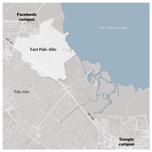 East Palo Alto - in between Facebook and Google
Through “rebooting history” we are taking this large body of documentation, looking at it through this spatial history lens and exploring it anew through projects that bring Stanford students and EPA community members together through classes, video projects, mapping, oral history and other interactions that deepen, enrich and refresh our view of both East Palo Alto and its interrelations with the larger Silicon Valley region.
Rebooting History Summer Program
Rebooting History’s Summer Program for 2012 explore ones of the most dramatic and long-term aspects of East Palo Alto’s spatial narrative – the aftermath of the 1976 closure of Ravenswood High School that left the community without a public high school as a community anchor institution.
As a result, the majority (and till recently, all) East Palo Alto high school students go out from their community on a daily basis for their education to some 18 different schools.
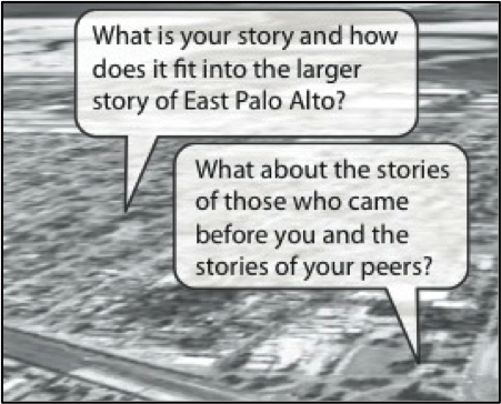 From outreach flyer for the 2012 Summer Program
To explore this history, we recruited a team of current East Palo Alto high school students from five of these different schools and trained them in the oral history methodologies developed at Voice of Witness, an organization co-founded by novelist Dave Eggers that uses oral history as a way to explore human rights issues. The youth then conducted interviews with earlier cohorts of East Palo Altans about their high school experiences to better understand what it meant to have your own high school and to lose it and the spectrum of experiences shaped by this story. Nine interviews were conducted with East Palo Altans who had attended high school as long ago as the late 50s and as recently as 2005.
The Summer Program is being used as a prototype that will be continued on a larger basis next year with the goal of eventually creating a published oral history on the East Palo Alto high school experience as a distinctive Silicon Valley story.
Urban Studies 166 - East Palo Alto: Reading Urban Change
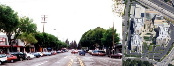
This course, co-taught by Michael Levin and urban historian Michael Kahan, was the first in an intended annual series of topical courses exploring the process of change in East Palo Alto. This past year’s course brought together Stanford Urban Studies students and East Palo Alto youth in the Mural Music and Arts Program to look at how East Palo Alto’s Whiskey Gulch small business district was demolished to make way for the University Circle hotel/office complex as part of the City’s redevelopment effort.
The collaborative output of the course were three documentary/music videos edited by the Stanford students using footage shot by Michael Levin with sound tracks created by the East Palo Alto youth. The goal was to create a nuanced expression of the themes of growth, change and loss inherent to the process of redevelopment. Read more about the outcomes of this inaugural course on the Stanford Arts site.
A next iteration of this course for Winter 2013 is currently in the works, this time focusing on East Palo Alto environmental stories including efforts to close a local hazardous waste recycling facility, support the growth of local urban agriculture, and reopen the historic Cooley Landing waterfront area to the public.
A Spatial History of Ravenswood
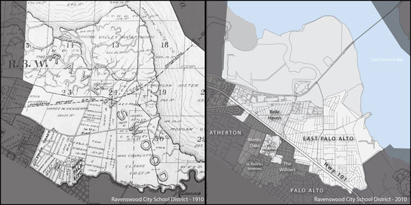
The latest and most geospatially-intensive project partners Michael Levin with Spatial History Project cartographer/geographer Jake Coolidge to explore the impact of the Bayshore Freeway on the Ravenswood City School District in bifurcating the original district (shown above, left) leading to a process beginning in 1976 and continuing to this year of areas west of 101 transferring into the Menlo Park City School District. Today only a few areas west of Bayshore are still part of Ravenswood (above, right) and the project will attempt to explore what this has meant for both communities and for the region.
Support for Rebooting History comes from the Presidential Fund for Innovation in the Humanities and the Vice Provost for Undergraduate Education.
Rebooting History builds on nearly 20 years of documenting the process of urban change in East Palo Alto. The effort began with the production of the award-winning 1996 documentary Dreams of a City: Creating East Palo produced by Michael Levin for Stanford University Libraries and the Committee on Black Performing Arts.
In 2011, Prof. Zephyr Frank, Director of the Spatial History Project, invited Michael Levin to continue his work on East Palo Alto at the Project and incorporate a new geospatial focus on a how a convergence of space, race, economics and history shaped the development of the community and how exploring this process might allow for new ways of understanding it.
East Palo Alto - in between Facebook and Google
Through “rebooting history” we are taking this large body of documentation, looking at it through this spatial history lens and exploring it anew through projects that bring Stanford students and EPA community members together through classes, video projects, mapping, oral history and other interactions that deepen, enrich and refresh our view of both East Palo Alto and its interrelations with the larger Silicon Valley region.
Rebooting History Summer Program
Rebooting History’s Summer Program for 2012 explore ones of the most dramatic and long-term aspects of East Palo Alto’s spatial narrative – the aftermath of the 1976 closure of Ravenswood High School that left the community without a public high school as a community anchor institution.
As a result, the majority (and till recently, all) East Palo Alto high school students go out from their community on a daily basis for their education to some 18 different schools.
From outreach flyer for the 2012 Summer Program
To explore this history, we recruited a team of current East Palo Alto high school students from five of these different schools and trained them in the oral history methodologies developed at Voice of Witness, an organization co-founded by novelist Dave Eggers that uses oral history as a way to explore human rights issues. The youth then conducted interviews with earlier cohorts of East Palo Altans about their high school experiences to better understand what it meant to have your own high school and to lose it and the spectrum of experiences shaped by this story. Nine interviews were conducted with East Palo Altans who had attended high school as long ago as the late 50s and as recently as 2005.
The Summer Program is being used as a prototype that will be continued on a larger basis next year with the goal of eventually creating a published oral history on the East Palo Alto high school experience as a distinctive Silicon Valley story.
Urban Studies 166 - East Palo Alto: Reading Urban Change
This course, co-taught by Michael Levin and urban historian Michael Kahan, was the first in an intended annual series of topical courses exploring the process of change in East Palo Alto. This past year’s course brought together Stanford Urban Studies students and East Palo Alto youth in the Mural Music and Arts Program to look at how East Palo Alto’s Whiskey Gulch small business district was demolished to make way for the University Circle hotel/office complex as part of the City’s redevelopment effort.
The collaborative output of the course were three documentary/music videos edited by the Stanford students using footage shot by Michael Levin with sound tracks created by the East Palo Alto youth. The goal was to create a nuanced expression of the themes of growth, change and loss inherent to the process of redevelopment. Read more about the outcomes of this inaugural course on the Stanford Arts site.
A next iteration of this course for Winter 2013 is currently in the works, this time focusing on East Palo Alto environmental stories including efforts to close a local hazardous waste recycling facility, support the growth of local urban agriculture, and reopen the historic Cooley Landing waterfront area to the public.
A Spatial History of Ravenswood
The latest and most geospatially-intensive project partners Michael Levin with Spatial History Project cartographer/geographer Jake Coolidge to explore the impact of the Bayshore Freeway on the Ravenswood City School District in bifurcating the original district (shown above, left) leading to a process beginning in 1976 and continuing to this year of areas west of 101 transferring into the Menlo Park City School District. Today only a few areas west of Bayshore are still part of Ravenswood (above, right) and the project will attempt to explore what this has meant for both communities and for the region.
Support for Rebooting History comes from the Presidential Fund for Innovation in the Humanities and the Vice Provost for Undergraduate Education.
Former Research Assistants:
Rameerah Anderson, Maxine Fonua, 'Amelia Kolokihakaufisi, Najja Kossally, Jonathan Lautaha, Joanna Leon, Marco Medellin, Alexis Z. Romero

CESTA | Spatial History Project
Wallenberg Hall, 450 Serra Mall
Mail: Bldg 160, Rm 228 - In Person: Fourth Floor
Stanford, CA 94305-2055

Mail: Bldg 160, Rm 228 - In Person: Fourth Floor
Stanford, CA 94305-2055
©2007-2022 The Spatial History Project All Rights Reserved
The Spatial History Project at Stanford University, a part of the Center for Spatial and Textual Analysis, was made possible by the generous funding of the Vice Provost for Undergraduate Education (VPUE), DoResearch, The Andrew W. Mellon Foundation, and The Wallenberg Foundation Media Places Initiative.
v3