This website is no longer updated and has been replaced with a static copy. The Spatial History Project was active at Stanford University from 2007-2022, engaging in dozens of collaborative projects led by faculty, staff, graduate students, post-docs, visiting scholars and others at Stanford and beyond. More than 150 undergraduate students from more than a dozen disciplines contributed to these projects. In addition to a robust intellectual exchange built through these partnerships, research outputs included major monographs, edited volumes, journal articles, museum exhibitions, digital articles, robust websites, and dozens of lightweight interactive visualizations, mostly developed with Adobe Flash (now defunct). While most of those publications live on in other forms, the content exclusive to this website is preserved in good faith through this static version of the site. Flash-based content is partially available in emulated form using the Ruffle emulator.
Boundaries of Nature
This project investigates the spatial and environmental history of the establishment of the Iguazú National Park in Argentina and the Iguaçu National Park in Brazil. The parks were created in the 1930s in a region of tropical moist forest straddling the border of the two countries. Through the use of a wealth of historical maps, aerial photographs, and satellite imagery, our project aims to understand and compare the effects of colonization and conservation policies on these two protected areas and their surrounding landscapes from the 1930s to the 2000s.
Former Lab Staff:
Celena Allen
Former Research Assistant:
Peter Salazar

GALLERY:
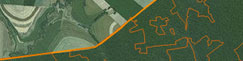
Landscape Change in Southern Brazil, from 1953 to the Present Day