This website is no longer updated and has been replaced with a static copy. The Spatial History Project was active at Stanford University from 2007-2022, engaging in dozens of collaborative projects led by faculty, staff, graduate students, post-docs, visiting scholars and others at Stanford and beyond. More than 150 undergraduate students from more than a dozen disciplines contributed to these projects. In addition to a robust intellectual exchange built through these partnerships, research outputs included major monographs, edited volumes, journal articles, museum exhibitions, digital articles, robust websites, and dozens of lightweight interactive visualizations, mostly developed with Adobe Flash (now defunct). While most of those publications live on in other forms, the content exclusive to this website is preserved in good faith through this static version of the site. Flash-based content is partially available in emulated form using the Ruffle emulator.
Morgan Oyster Holdings, 1909: Height of Bay Oyster Industry
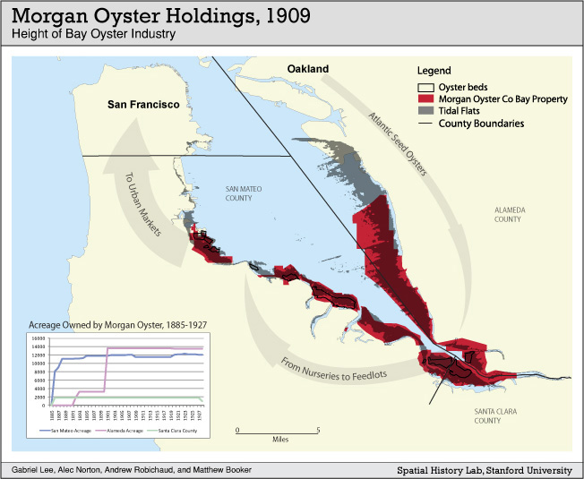
Authors: Gabriel Lee, Alec Norton, Andrew Robichaud, and Matthew Booker
By the first decade of the twentieth century, oyster production in San Francisco was a virtual monopoly, controlled by the Morgan Company. Given the size of the Bay, how was it possible that a few oyster beds on the western shore constituted a monopoly of production? Why didn't oyster growers use other parts of the Bay? By mapping possible oyster habitat and bay ownership, this project got closer to answering those questions, and opened a network of new historical questions. Using historical bathymetry data this project mapped possible oyster habitat (defined as two feet above and below "mean low tide" using documented criteria of oyster producers as well as the location of actual beds). Maps of assessed property show that by 1909 Morgan controlled virtually all of the productive oyster space within San Francisco Bay.