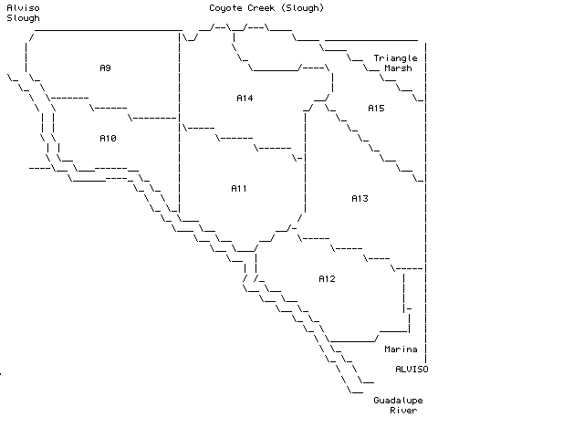
North is at top. The focus of this map is the set of ponds that are surrounded by the Alviso Slough Trail. Access to this area is the Alviso Marina at the end of Gold Street in Alviso. Unlike almost all the other Cargill ponds in the South Bay these ponds are largely accessible to the public as the San Francisco Bay National Wildlife Refuge owns the land and Cargill has salt evaporation rights to the ponds. Originally, the ponds were numbered in order of increasing salinity, but the flow is managed differently now and A9 is also an inlet pond, just like A1. But there is a general flow from west to east and the ponds further east (see Alviso Salt Ponds, Part 3) are more saline. Coyote Creek (most people call it a slough this far into the bay) is the top border of the map and has its confluence with Alviso Slough in the upper left corner. Beyond Coyote Creek is Alameda County and more salt ponds, but that is beyond the range of these maps and commentary.
Alviso Slough drops down from the upper left to the lower right corner where it turns into the Guadalupe River. To the left of Alviso Slough are the salt ponds associated with the Knapp Tract (see Alviso Salt Ponds, Part 1). On the right are the railroad tracks. In the uppper right corner is a fairly extensive marsh with lots of cordgrass that is called Triangle Marsh. It often contains American Bittern in the winter (unless you are specifically looking for them) as do the marsh margins along Alviso Slough. Just to the north of the marina is a seasonal impoundment that often has interesting birds and is close enough to the marina for a quick check. It is originally part of the New Chicago Marsh, but was cut off by the railroad tracks. You can make either a clockwise or a counterclockwise loop around these ponds, but, for the most part, you cannot use the levees between the ponds.
At the marina itself a sign has been posted in some years that says that the clockwise route is closed because of soft mud. If the sign bothers you then take the counter-clockwise route and you will find on your return that you can't read the sign from the other side. The loop is nine miles, so be forewarned. The conventional wisdom is that the best birding is on ponds A9 and A14 which means you have to go all the way out. In my experience the trip out is three miles, no matter which direction you take, while the trip back is six miles. Conventional wisdom also holds that it is better to bicycle than to walk. This is good advice except when the mud hasn't dried out after a winter rain-- then everyone walks. Water height has something to do with pond attractiveness, fish blooms, and available shorebird roosting habitat. These levels are determined by the Cargill Salt Master, a mythical person who adjusts these levels to attract birds for us. The tide also has an important effect on shorebirds that feed on the bay and roost in these ponds. There is an entry pipe on the Alviso Slough side of A11 that sometimes has pickle flowing out plus other delectables - I assume dismembered fish caught in the pumps. This can be attractive to the small gulls when it is flowing. [WGB, 2 Jan 97]