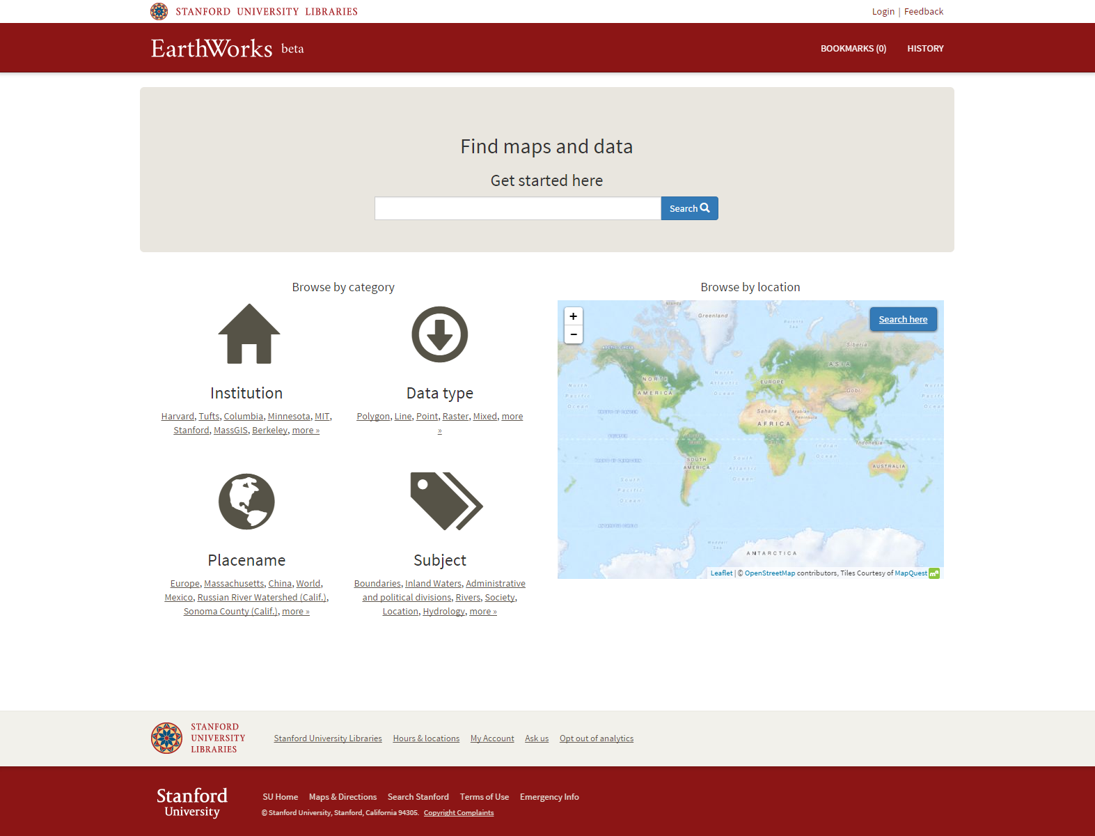
EarthWorks.stanford.edu
geospatial data is different
it has geometry
and scale
and extent
and temporality
It's difficult to find
It's difficult to evaluate
It's difficult to access
EarthWorks is Stanford's simple, effective web application for discovery of geospatial data
EarthWorks
focuses on discovery of geospatial data.
not analysis
find it
evaluate it
access it
in EarthWorks you search for geospatial data with a map!
search results are ranked based on the
map scale and extent!
layer-level
discovery
preview the data in the application
exposes
attributes and
metadata
federated search allows you to discover geospatial data from other institutions
(harvard, tufts, mit, berkeley, columbia...)
Why is EarthWorks different?
EarthWorks
is built
for libraries
by libraries
EarthWorks begins with
preservation
EarthWorks is powered by the SDR
(Stanford Digital Repository)
The SDR is Stanford's Fedora-based preservation repository for scholarly content
The SDR treats digital assets as durable assets
every data deposit in the SDR gets a PURL!
(persistent URL)
PURLs make geospatial data citable and accessible in perpetuity
EarthWorks makes geospatial data discoverable
and the
Stanford Spatial Data Infrastructure (SSDI) that drives EarthWorks...
...makes geospatial data operational!
The SSDI is based upon the
OpenGEO Suite
PostgreSQL
PostGIS
GeoServer
The SSDI exposes live OGC spatial data services
(WFS, WMS, etc...)
so the same infrastructure that preserves our geospatial data can drive data to applications
let's
hack EarthWorks a little and see what that means...
EarthWorks is our Stanford branded implementation of the Open Source software called GeoBlacklight
the GeoBlacklight project is based upon the Project Hydra framework for Fedora Repositories
GeoBlacklight code contributers include:
Stanford, Princeton, MIT, and NYU
Even the metadata in EarthWorks is maintained in an Open and Consortial repository on GitHub called OpenGeoMetadata
OpenGeoMetadata currently contains metadata for ~50,000 data layers...
contributed by
Stanford, Princeton, Harvard, UVA and Tufts...
with NYU, UMN and The British Library ready to begin contributing.
How to get involved?
Baby Steps...
GeoBlacklight Institutions will index your metadata and make your holdings searchable
Launch your own GeoBlacklight instance...
Be part of the GeoBlacklight Community!
Come to Stanford for
Geo4Lib Camp 2016
Geo4Lib CampWhen:
January 25-27, 2016
Who:
GIS developers, librarians, managers
Modeling GIS data using Hydra/Fedora
Creating and managing GIS metadata
Discovery services with GeoBlacklight
Building a spatial data infrastructure
Working with your data and metadata
and more...
what's next?
- Automated Ingest
- Self Deposit
- Crowdsourcing!
- Georeferencing
- Vectorization
- Attribute Transcription
- Modeling derivative relationships
 Metadata
is
Sexy!