geo:0.1::254

Stabilization of sea level about 6000 years ago
resulted in the
formation of deltas and floodplains providing for the first time
conditions suitable for highly organized human society. Yet the early years of civilization
were marked by unstable behavior of lower river valleys influenced by erratic global climate
as well as transition of rivers into their present meandering form. Many human practices and
beliefs are rooted in the late fourth millenium (~3200 BC). And many of our most pressing
urban and environmental problems today, including floods,arise from these same ancient events.
geo:0.15:an106.gif:256
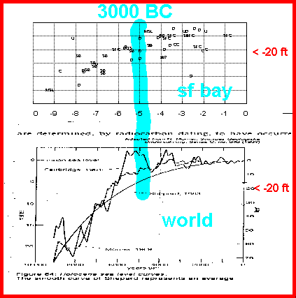
The inconstant sea: we begin with late Holocene sea levels and their effect on human geography.
The graph shows C14 dates for muds and vegetation in the San Francisco Bay and delta; C14 dates have been corrected to give calendar years, and the effects of autocompaction have been removed.
A recent survey of 36 world wide Holocene deltas indicates that delta formation began about
8000-6000(cal) years ago (6000-4000 BC)when sea level was roughly 50 ft.
below present level. This was the beginning of human geography as we know it today.
geo:0.4:sealev.gif:204

Delta formation: rivers deposit sediment in their
deltas (i.e. at the point where the river meets the ocean, bay or lake). Gradually the river
builds outward getting longer and flatter. Contrary to what intuition might suggest, the
river ends up higher than the adjoining floodplain! When the ever-lengthening river finally
overtops its natural levee (a crevasse) a new, shorter, and more efficient channel is
the result.
geo:2:lf1.gif:126
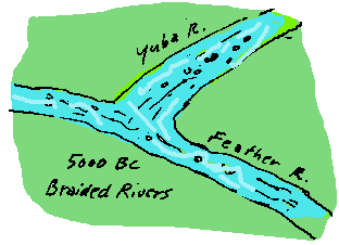
Returning to 6000 BC: In those days when giants
walked the earth the streams were fast running and braided, with long straight gravelly
stretches, much like the streams in mountain valleys today. The gravels were highly pervious,
that is good carriers of water, and are still tapped as sources of water for farm and
domestic wells.
geo:3.8:a1.gif:31
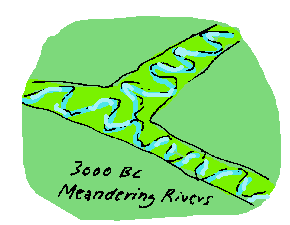
Then at about 3000 BC a combination of global events, including sudden climatic change, floods, and possibly meteor impact, shocked the rivers into a new type of flow.
Major rivers
throughout the world began to meander,
swinging back and forth in their channels.
geo:3.9:b1.gif:32
A longitudinal profile of the river is
revealing. Discontinuities in sea level or flooding result in discontinuities in stratigraphy
within the Holocene section. In California a key feature is the midholocene delta that
builds below Sacramento at about 4000 BC.
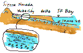
geo:4:lf31.gif:162
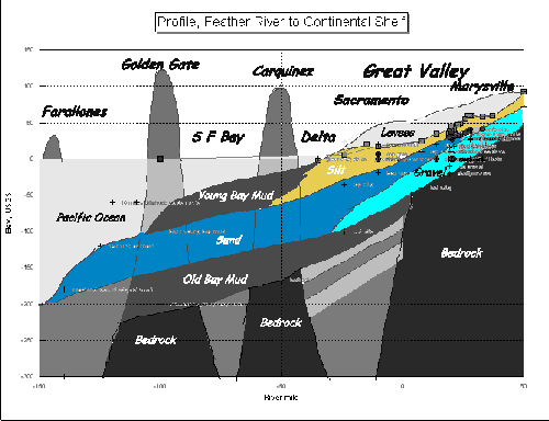
Profile from the Sierra Nevada to the continental shelf. Notice the gravel layer, remnant of the late Pleistocene, say 15,000 years ago. This is the key to levee stability because it carries water under the levees and causes sand boils and uplift pressures on the land side of the levee.
The profile is remarkably similar to other river profiles including the Rhine, Nile, Indus,
and Euphrates.
geo:4.1:profile2.gif:253
How does the failure behavior of the levees
during flooding demonstrate that these geologically-inferred gravel layers are present?
geo:4.2:lf7.gif:257
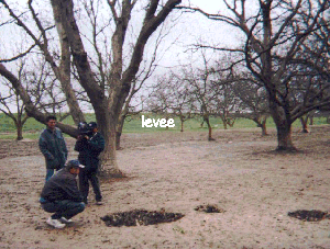
Answer: this is the only way that sand boils and
collapse features can show up hundreds or thousands of feet on the land side of failure-prone
levees. Here is one (discovered by my 11 year old son Kevin) being photographed for KPIX a
few hundred feet downstream from the Arboga collapse of January 1997. Ours were the first
footprints in this orchard, many weeks after the failure. Why wasn't this clear warning sign
being investigated?
geo:4.21:crew.gif:258
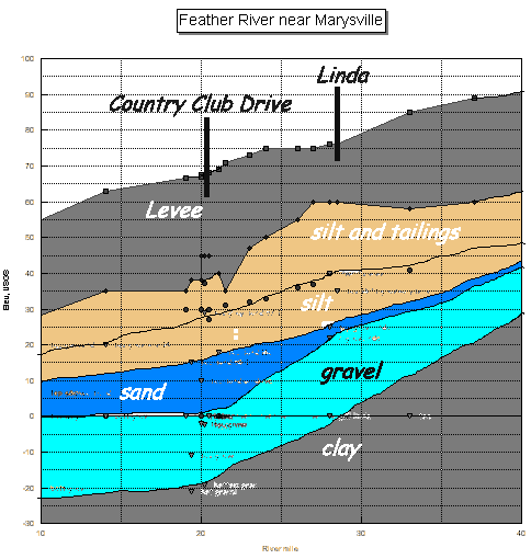
More geology: a longitudinal profile of a 20
mile stretch of the Feather River centering on the Arboga failure at Country Club Road.
Notice that at both the Country Club Road and Linda failures the levee is built on a silt
(and tailings) layer (brown color) whicih is roughly as thick as the levee is high.
geo:4.3:profile1.gif:180
In anticipating failure D, the fatal combination
occurs where the levee intrudes onto the floodplain, is built on a silty cap (covering old
gravel), that is relatively thin. These areas are marked by low ground and high groundwater,
C.
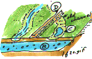
geo:10:lf20.gif:152

The potential ratio of underseepage pressure to top stratum thickness can be identified in various ways, by examining aerial photos for low marshy areas indicative of former river channels, or by topographic profiling as in the illustration of the left bank of the Yuba-Feather, where the conditions corresponding to the 1986 and 1997 failures are quite clear.
Would you like to see something on levee failure mechanics?
geo:15:lf21.gif:153
Quiz: now that you have learned all this, can you tell why the pattern of levee failures of January 1997 is the way it is?
Would you like to see something on levee failure mechanics?
On how I learned this stuff from a hard lesson in 1963?
On how the Sumerians and the Hebrews learned the same lesson in
3200 BC?
geo:16:failmap.gif:259
Questions or Comments?