
0.5:aneqlev5.gif:674

We are examining here some levee failures that occur
along the dangerous blue-tinted "levee failure belt" in California and elsewhere.
1:mfa1.gif:611

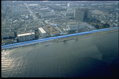
We focus on three deadly failures north of Sacramento
near the Gold Rush city of Marysville
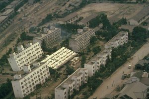
2:mfa2.gif:612

Thirty years after the famous "Christmas Eve" failure
that flooded Yuba City, a similar failure happened in a similar geographic area on the other side
of the river.
3:mfa3.gif:613
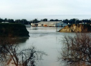
Photo of the 1986 Linda Levee after failure.
4:mfa4.jpg:614
None of the failures we are discussing involved
overtopping of the levee. In fact, the history of levee failures in the U.S. indicates 50-75
percent of failures occur when the river is below the crest of the levee. Eyewitnesses agreed on a
sequence of events like this.
5:mfa5.gif:615

How exactly do they fail? One traditionally
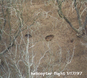
conceived failure made is embankment seepage occasioned by seepage through the levee itself,
aggravated by those great scapegoats of levee failure, ground squirrels.
6:mfa6.gif:616

But for decades levee failures have been associated
with sand boils which do not appear to be related to the levee itself.
7:mfa7.gif:617

Studies by the Corps of Engineers on the Mississippi
indentified a process of failure that involved underseepage as a fundamental start of the failure
process.
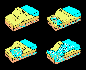
8:mfa8.gif:618

It wasn't the first time I had pondered the
destruction of levees. In the mid sixties as young engineer I had built a whole system of them in
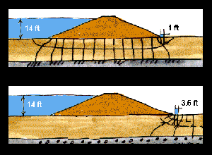
Thailand. They looked very handsome in the dry season.
8.1:img0041s.jpg:663
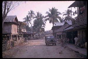
Here is the village of Takhop where we lived-- in
the dry season.
8.15:img0035.gif:671
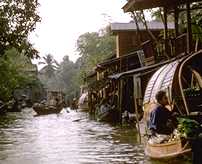
The rainy season was a different story; many of
my levees failed inundating our village. Fortunately the people were quite used to these sorts of
problems there, but I was left with a problem of how to do the job better.
8.2:img0046s.jpg:668
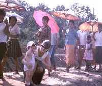
One day there was a festival and I was taking a
photo of my daughter standing on one of the levees
8.3:img0033s.jpg:664
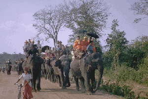
Suddenly down the road a line of elephants
appeared, giving me a possible answer to the levee failure problem.
8.4:img0040.gif:672

We did appropriate tests of elephant soil
compaction capability (ultimately featured in the new Yorker Magazine as a kind of joke). We wrote a
paper on the matter. (Click here for
more on this).
8.5:Img0001.gif:673
Meanwhile I found that studies by the California's
Department of Water Resources in yearss past had identified an entirely different problem --
seepage that killed orchard crops after floods. It seemed to identify exactly the same condition
that occurred in floods.
9:mfa8a.gif:619

Another clue was the apparent delay in the Linda
failure -- nearly a day a year the flood peak had passed.
10:mfa9.gif:620

These ideas led me to conclude that the failure was
a foundation failure -- brought about by deep foundation seepage followed by piping out of a large
enough cavity to permit settlement of the levee.
11:mfa10.gif:621
During the several days of trial questioning I
commented that another area that looked ripe for failure was down river a few miles at Arboga.
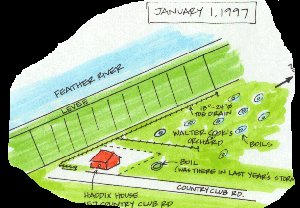
12:mfa11.gif:622

This prediction proved to be true. The day after New
Years 1997 the levee broke at that very point.
13:mfa12.jpg:623

.causing the usual toll of death, property damage,
and misery.
14:mfa12a.jpg:624

The break occurred just where history.
15:mfa13.jpg:625

.and geology suggested it should. See
http://www.stanford.edu/~meehan/flood/aeg.html for more on this.
16:mfa15.gif:626

Leading to fame for a day.
17:mfa14.gif:627
But I was not satified that I understood just what
had happened in the fialure process. Here we had more eye witness history and testimony, featuring
extensive boils.
18:mfa15.gif:628

Some quite tiny.
19:mfa16.gif:629

Others evolving into sinkholes
20:mfa17.gif:630
Visible from the air.
21:mfa18.gif:631

and on the ground.
22:mfa19.jpg:632

Interestingly similar patterns of boils were known
to develop in earthquakes as here in the Pajaro River during the Loma Prieta quake.
23:mfa20.gif:633

They also suggested future levee failures -- as
shown at Pajaro. (Note the correspondence of the failure with the intersection of the county line
with the levee; this interesting coincidence is explored in
http://www.Stanford.edu/~meehan/parajo/index.html)
24:mfa21.gif:634

Many people laughed at the claims by flood victims
that just before the failure snakes come out of the ground. People thought "Go tell that to your
bible class."
25:snake.gif:646
The comparison to Pajaro raised some interesting
thoughts. Thinking laterally for a moment, we note that in earthquakes boils = liquefaction of soil
= buildings tipping in Japan.
27:mfa22.jpg:635
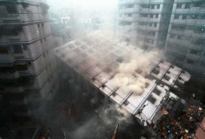
.in Taipei, and at almost any other earthquake
affecting an urban area in a lower river valley.
28:mfa23.jpg:636

Combining all these ideas suggests the following
sequence: rising water and foundation recharge.
29:mfa24.gif:637

.leading to boils.
30:mfa25.gif:638

.and finally to foundation bearing capacity failure.
31:mfa26.gif:639

The traditional standard flownet suggesting low
uplift pressures at the toe
31.1:stfn.gif:665
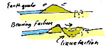
Bearing capacity failures of levees following
earthquakes provide important insights
31.2:eqbf.gif:666

.leading to a new model of flood failure.
31.3:newmod.gif:667
Concentration of upward seepage beneath the toe of a
sound, tight levee is the most dangerous.
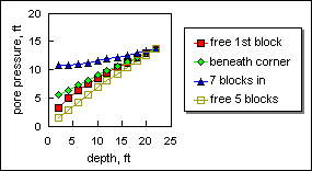
32:mfa27.gif:640
Computer modeling shows that complete liquefaction
occurs with upward gradients of less than 0.5 toe failure from loss of bearing capacity happens at
even lower gradients.
33:mfa28.gif:641

As suggested previously the pressure in the gravel
driving the upward gradient will eventually reach somewhere between 50 and 100 percent of the river
level, the latter where the river accesses the gravel in its natural channel or through artificial
pits, which have been long and wisely banned.
34:mfa29.gif:642
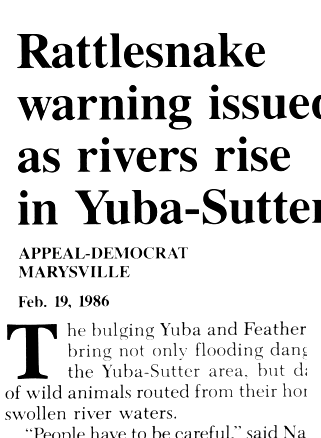
It was clear that the reptiles were able to
foretell the failure.
34.5:snake1.gif:647

Except where rich quarry owners are able to change
the rules. Or in the case of the 1997 failure where wetland restorationism prevails over
engineering principles.
35:mfa30.gif:643

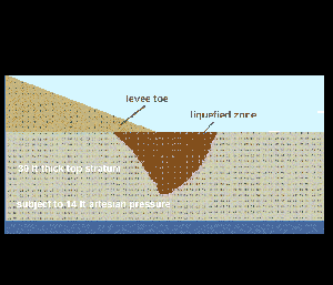
Toe liquefaction under 18 ft uplifet, 30 ft
non-stratified topstratum. See flowneta.wk4
36:mfa31.gif:644
Pore pressures rise and fall beneath the toe of the
levee
37:pp.gif:645
The Osaka earthquake destroyed many of the levees
that protect the city. Fortunately for the residnets the river level was low and there was no
catastrophic flooding.
38:osakalev.gif:648
State studies after the 1997 flood called for levee
repair schemes that seemed unlikely to solve the problem. Certainly the type of slurry wall shown
here would do nothing to prevent the type of failure that happened at Marysville.
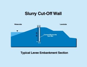
39:slurry.jpg:649

This is a little better, but still of questionable
value.
40:tdrain.jpg:650

Comparable floods struck the Central Valley in the
last century
205:t110b.gif:659
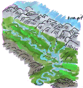
Comparable floods struck the Central Valley in the
last century
207:t110.gif:660
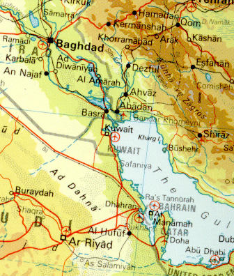
Mesopotamia
210:sfckar3.gif:654

Imperial Valley
212:imperi.gif:652

Santa Clara Valley
215:sfckar2.gif:653

I learned that you don't want to dig holes in the
ground on the water side of the levee.
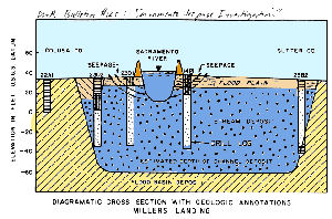
300:boilfail.gif:670

A lesson learned 35 years ago at LamPra Plerng
310:63.jpg:656

And remembered today.
320:98.jpg:657
Questions or Comments?