SAN FRANCISCO PLANS
1. Plan of
major residential areas
2. Plan of Presidio 1776
3. Plan of Yerba Buena 1835
4. Vioget’s plan of Yerba Buena/San Francisco 1839
5. O’Farrell’s plan 1847
6. Plan of 1848, showing what
had been built by then
7. View of SF from the bay
1847
8. O’Farrell & Eddy’s
plan 1849, showing proposed extension S of Market Street
9. Plan showing landfill
sites
10. Plan c.1856, showing proposed
Western Addition (north is to right)
11. 1861 plan of ciry
and county of SF (north to right)
12. Birds-eye view 1878
13. Plan of Golden Gate Park and ‘panhandle’ 1870-1
14. Birds-eye view
of Golden Gate park 1892
15. Birds-eye view looking N from
Mission Bay
16. Map of China town 1884-5
17. Early-C20 photos of Victorian
houses
18. Daniel Burnham’s
plan 1905
19. Burnham’s plan
for the Civic Centre
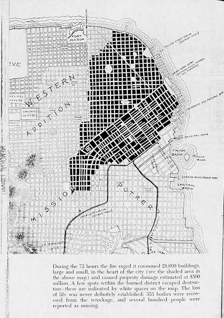
20. Plan showing area damaged in
1906 earthquake
21. Plan of new streets proposed
by citzens’ committee 1906
22. Plan of Civic Centre
as executed 1913
23. Plan showing population
distribution and public transport routes 1912
24. Table showing ethnic
origins of SF population in late C19
25. Table of occupations
1900
26. Birds-eye view of proposed Bay
Bridge 1925