Imago Urbis: Visualizing the City
Two Modes for Imagining 18th Century Rome
Rome is the most thoroughly documented city in the world. Artists and chroniclers have represented this city for millennia and have left a vivid visual record of their impressions. Fundamentally they have used two means for making their observations permanent: they have recorded it pictorially as a series of more or less realistic scenes, using perspective, or cartographically, as an abstract drawing in plan that required scaled measurements. During the 18th century Nolli stands alone as the brilliant protagonist of the plan view but despite his achievement he could not compete with the popularity and commercial success of the artists who portrayed the city pictorially. The 18th century was the age of the vedutisti, artists who represented the city through carefully rendered vedute or city views typically showing sites in their urban context. These urban portraits were executed with astonishing accuracy, detail and attention to ephemeral qualities such as lighting effects. Artists working within this genre such as Canaletto (1697-1768) in Venice and Piranesi (1720-1778) Venetian but working in Rome, helped to define the artistic tenor of the age. Vivid portrayals of daily life or fantastic recollections of a vanished city enriched the pictorial composition. The first providing a valuable social record, the second disclosing attitudes about Rome and its continued cultural legacy. Because it was topographically based, the tradition of the vedutisti could intersect the cartographic tradition, the volo d'ucello or bird's eye view, being an important type where both the pictorial and plan view are conceptually united in a single work. An example of such an approach is Giovanni Battista Falda’s (1640-1678) “Nuova pianta et alzata della città di Roma…” of 1676 which shows the city in a plan projection view.
Giambattista Nolli and La Pianta Grande (1748)
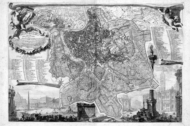
Vasi's contemporary, Giambattista Nolli (1701-1756), was a surveyor, cartographer and architect who lived in Rome and devoted his life to documenting the architectural and urban foundations of the city. The fruit of his labors, La Pianta Grande di Roma (literally "the great plan of Rome") is one of the most revealing and beautiful urban plans of all time. It is the first accurate map of Rome and captures the city at the height of its cultural and artistic achievements. Because the historic center of Rome has changed remarkably little over the last 250 years, the Nolli map still remains one of the best sources for understanding the contemporary city.
The Nolli map was engraved on twelve exquisitely engraved copper plates, and when the sheets printed from these are combined the result is an image that measures 176 cm by 208 cm. Surveying almost eight square miles of rolling terrain which included dense city fabric, surrounded by a sparsely populated but intricate pattern of farms, vineyards, villas, monasteries and ancient ruins, and indexing 1320 sites, Nolli achieved an extraordinary technical feat that represents a milestone in the art and science of cartography. Modern surveys and sophisticated satellite images have confirmed the accuracy of Nolli's map within the smallest margin of error. In addition to recording the streets, squares and public urban spaces of Rome, Nolli carefully rendered hundreds of building interiors by way of detailed plans that emphasizes their significance for the larger public realm. This transparent view of both outside and inside ensures the map's continuing value as a unique historical document that gives the viewer a vivid "Pompeii-like" glimpse of daily life in a great metropolitan center during one of its most illustrious periods. Nolli collaborated with Piranesi in producing a smaller version of this map, the Piccola Pianta, begun in 1747, but published with the larger map in 1748.

La Piccola Pianta di Roma di Giovanni Batista Nolli 1748. (with architectural capricci by Piranesi)
Courtesy of the Getty Research Institute.

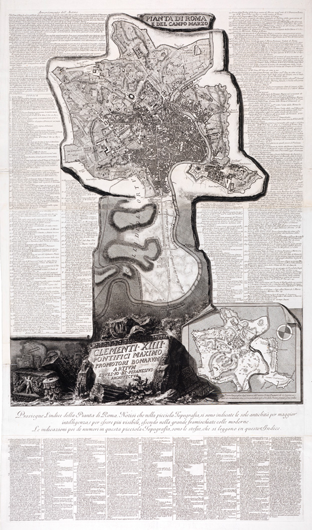
Pianta di Roma e del Campo Marzo Giovanni Battista Piranesi, c. 1774
Courtesy of the Getty Research Institute.
A quarter of a century after Nolli published his Piccola Pianta, Piranesi used an almost exact copy to produce the upper half of his map which is extended to include the northern portion of the city, encompassing the Ponte Milvio. The scales of the two plans are identical and the graphic conventions are almost the same suggesting that Piranesi simply traced the Piccola Pianta. The differences between the two maps are subtle but significant. Piranesi, as the antiquarian, lists 402 items which all refer to ancient sites. Nolli lists a mere 10 ancient sites out of a total of 170 in his index
.
Giuseppe Vasi and Delle Magnificenze di Roma (1744-1761)
Born in Corleone, Sicily, Giuseppe Vasi (1710-1782) worked in Rome and was a contemporary of other great vedutisti such as Panini and Piranesi. He is best known for his extensive vedute of Rome that collectively serve as an admirable pictorial companion to Nolli's Grande Pianta. In particular, the 238 prints in his ten-volume Magnificenze di Roma antica e moderna give such a clear, capillary impression of the city, that their totality might almost be described as Nolli in three dimensions. The reciprocity between Vasi's views and the Nolli map enables one to enter into, and examine Rome in detail, including many neglected corners of the Settecento city. Passing from map to view and from view to map, one can reconstruct 18th century sites that have since changed completely or entirely disappeared.
Relationship between Nolli and Vasi's Work
The 18th century was the Age of the Grand Tour and Romans played host more than any other Europeans to this phenomenon. It was the vedutista, Giuseppe Vasi, who provided the most complete pictorial view of the city's streets, churches, palaces and monuments that were the objects of the visitor's cultural odyssey. His contemporaries and collaborators, Giambattista Piranesi and Giambattista Nolli contributed their own unique vision of the city. Despite the fact that Piranesi's more dramatic views have historically eclipsed those of his mentor and later rival, it is Vasi's vedute, not Piranesi's, that serve as the more useful pictorial companion to the Pianta Grande. Nolli's 1748 map perfects the ichnographic plan giving a minutely detailed orthographic projection view of the city while Vasi's exhaustive perspective views dating from 1747 to 1761 reveal a remarkable parallel development in three dimensions yielding a vast composite landscape. Together these two masters provide a vivid and highly instructive image of Rome's architectural and urban legacy, one that ravished the 18th century visitor and one that still cannot fail to stir the imagination of the 21st century observer.

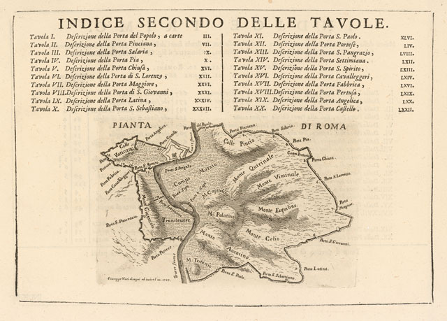
"Masurements of the distances between city gates supplied to the author of this work by the architect and surveyor Gio. Battista Nolli from Como." from Le Magnificenze vol I, Giuseppe Vasi, 1747.
Courtesy of the Getty Research Institute.
The connection between the work of Nolli and Vasi is direct. Nolli contributed technical information for Vasi at the end of Volume I of the Magnificenze, recording the distances between city gates. Vasi's credits Nolli by noting, "Misura delle distanze da una Porta all'altra.favorite all'Autore di queste Descrizioni dall'Architetto, e Geometra il Sig. Gio. Battista Nolli Comasco" (“Masurements of the distances between city gates supplied to the author of this work by the architect and surveyor Gio. Battista Nolli from Comeo”). Most of Vasi's views date from the twenty-year period directly following the publication of the Grande Pianta, so Vasi evidently used this useful tool for his work.
The distribution of Vasi's views on the Nolli map yields an instructive pattern. Unlike Piranesi, who was interested principally in the majestic ruins and major monuments of Rome, Vasi systematically recorded buildings throughout the entire city and of all types, dedicating each of his ten volumes to a specific category. In doing so, Vasi did not limit his views to single buildings, but showed each of them in its urban setting, including adjacent structures, streets and piazze. While it may be argued that Piranesi's views are more striking in their splendid theatricality, from the topographer's point of view Vasi's more austere prints provide a more realistic sense of the 18th century city. Both artists use distortion, but Vasi's is perhaps more predictable: following in the steps of earlier view-makers such as Cruyl and Falda, he folds open streets book-like so that the buildings lining them can be more completely displayed. This obviously distorts the urban space, as occurs for example for Via dei Banchi (now Via del Banco di S. Spirito, Plate 109). But in general his views are faithful to the site and can be relied upon for even relatively fine details (e.g. the distant fašade of S. Maria dell'Orazione flanking the Palazzo Farnese, Plate 73). Whatever the departure from reality may be, the Nolli map serves to correct Vasi's perspectives by establishing an accurate topographic context.
|

