The EnergyAtlas: Mapping The World's Energy Infrastructure
With the EnergyAtlas, we aim to establish a global database with respect to conventional and renewable energy systems. Covering the supply, transmission, and demand side, the EnergyAtlas database will provide highly granular data for all regions of the world. By sharing our work openly, we hope to support researchers, policy makers, and business leaders in addressing the challenges linked to planning, operating, and optimizing the world's energy systems in the face of climate change.
Latest Announcements

OGNet has been published at the NeurIPS CCAI workshop.
Enriched Automated PV Registry has been published at NeurIPS.
DeepSolar for Germany has been published at IEEE's SEST conference.

DeepWind has been published at the NeurIPS CCAI workshop.

DeepGrid has been published at the NeurIPS CCAI workshop.
Background
Climate change poses tremendous challenges to the world, requiring a fundamental transformation towards clean and sustainable energy sources. While the rapid decarbonization of our energy systems mitigates the effects of climate change, new challenges linked to the integration of renewables and grid stability emerge. This is because existing power systems have been designed to accommodate centralized power plants only. Yet, many renewables, such as photovoltaic panels and wind turbines, are of a distributed and intermittent nature. Moreover, renewable energy sources are generally installed in smaller generation units and connected to the distribution grids. As a result, the electricity system has become increasingly complex, making forecasting and system operations ever more challenging. With the EnergyAtlas, we provide a tool for addressing many of these challenges.

A Selection of Current Projects
Research on Photovoltaic Systems
DeepSolar, 2018 [link to publication]
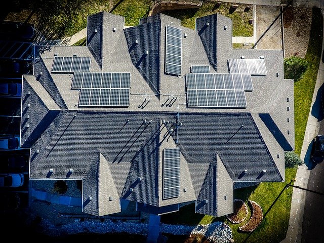
We developed DeepSolar, a deep learning framework analyzing satellite imagery to identify the GPS locations and sizes of solar photovoltaic panels. Leveraging its high accuracy and scalability, we constructed a comprehensive high-fidelity solar deployment database for the contiguous US. We demonstrated its value by discovering that residential solar deployment density peaks at a population density of 1,000 capita/mile², increases with annual household income asymptoting at ∼$150k, and has an inverse correlation with the Gini index representing income inequality. We uncovered a solar radiation threshold (4.5 kWh/m²/day) above which the solar deployment is “triggered.” Furthermore, we built an accurate machine learning-based predictive model to estimate the solar deployment density at the census tract level. We offer the DeepSolar database as a publicly available resource for researchers, utilities, solar developers, and policymakers to further uncover solar deployment patterns, build comprehensive economic and behavioral models, and ultimately support the adoption and management of solar electricity.
DeepSolar for Germany, 2020 [link to publication]
The increasing availability of high-resolution aerial imagery and the recent deep learning-based advances in computer vision have made it possible to automatically map energy systems remotely at a large scale. In this paper, we focus on optimizing the existing DeepSolar framework for photovoltaics (PV) system classification. Specifically, we propose an efficient dataset creation methodology for aerial imagery which allows us to achieve state-of-the-art results, improving the previous model's recall score by more than eight percentage points to 98% while keeping its precision almost constant at 92%. Furthermore, we show that our optimized model extends its superior classification performance to lower image resolutions. After re-training our optimized model on lower resolution imagery, we apply it to Germany's most-populous state, North-Rhine Westphalia, and deliver a proof of concept for automatically validating, updating, and creating databases of renewable energy systems at a large scale. We conclude with a brief analysis of socio-economic factors correlating with PV system adoption.
While photovoltaic (PV) systems are installed at an unprecedented rate, reliable information on an installation level remains scarce. As a result, automatically created PV registries are a timely contribution to optimize grid planning and operations. This paper demonstrates how aerial imagery and three-dimensional building data can be combined to create an address-level PV registry, specifying area, tilt, and orientation angles. We demonstrate the benefits of this approach for PV capacity estimation. In addition, this work presents, for the first time, a comparison between automated and officially-created PV registries. Our results indicate that our enriched automated registry proves to be useful to validate, update, and complement official registries.
Understanding solar adoption trends and their underlying dynamics requires a comprehensive and granular time-series solar installation database which is unavailable today and expensive to create manually. To this end, we leverage a deep siamese network that automatically identifies solar panels in historical low-resolution (LR) satellite images by comparing the target image with its high-resolution exemplar at the same location. To resolve the potential displacement between solar panels in the exemplar image and that in the target image, we use a cross-correlation module to collate the spatial features learned from each input and measure their similarity. Experimental result shows that our model significantly outperforms baseline methods on a dataset of historical LR images collected in California.
Research on Wind Energy
Wind energy is being adopted at an unprecedented rate. The locations of wind energy sources, however, are largely undocumented and expensive to curate manually, which significantly impedes their integration into power systems. Towards the goal of mapping global wind energy infrastructure, we develop deep learning models to automatically localize wind turbines in satellite imagery. Using only image-level supervision, we experiment with several different weakly supervised convolutional neural networks to detect the presence and locations of wind turbines. Our best model, which we call DeepWind, achieves an average precision of 0.866 on the test set. DeepWind demonstrates the potential of automated approaches for identifying wind turbine locations using satellite imagery, ultimately assisting with the management and adoption of wind energy worldwide.
Research on Fossil Fuels

At least a quarter of the warming that the Earth is experiencing today is due to anthropogenic methane emissions, with emissions from the oil and gas sector significantly contributing to the total anthropogenic methane budget. There are multiple satellites in orbit and planned for launch in the next few years which can detect and quantify these emissions; however, to attribute methane emissions to their sources on the ground, a comprehensive database of the locations and characteristics of emission sources worldwide is essential. Deep learning on remotely-sensed imagery has the potential to automatically detect and create a global database of oil and gas infrastructure.
Miscellaneous

Fine-Grained Distribution Grid Mapping Using Street View Imagery, 2019 [link to publication]
Fine-grained distribution grid mapping is essential for power system operation and planning in the aspects of renewable energy integration, vegetation management, and risk assessment. However, currently such information can be inaccurate, outdated, or incomplete. Existing grid topology reconstruction methods heavily rely on various assumptions and measurement data that is not widely available. To bridge this gap, we propose a machine-learning-based method that automatically detects, localizes, and estimates the interconnection of distribution power lines and utility poles using readily-available street views in the upward perspective. We demonstrate the superior image-level and region-level accuracy of our method on a real-world distribution grid test case.
Towards DeepSentinel, 2020 [link to publication]
Earth observation offers new insight into anthropogenic changes to nature, and how these changes are effecting (and are effected by) the built environment and the real economy. With the global availability of medium-resolution (10-30m) synthetic aperature radar (SAR) Sentinel-1 and multispectral Sentinel-2 imagery, machine learning can be employed to offer these insights at scale, unbiased to companyand country-level reporting. In this proposal, we document the development of an extensible corpus of labelled and unlabelled Sentinel-1 and Sentinel-2 imagery for the purposes of sensor fusion research. We make a large corpus and supporting code publicly available. We propose our own experiment design for the development of DeepSentinel, a general-purpose semantic embedding model. Our aspiration is to provide pretrained models for transfer learning applications, significantly accelerating the impact of machine learning-enhanced earth observation on climate change mitigation.