In San Francisco Bay, human beings have chosen a remarkably fecund but also unpredictable place to live. Sea level rise threatened by global warming is only the latest in a long history of environmental changes and societal adaptations in this region. Much of that complex history is forgotten. Two centuries of intensive land use have erased the bay shore and both shoaled and deepened the bay floor. In the process, the area's human and ecological pasts have been hidden.
This project aims to reveal those hidden layers of history. We bring together a variety of data to visualize the changing bay and shore over time. Through spatial analysis we hope to discover unseen patterns and connections and to raise new questions.
Our method is to visualize seemingly unrelated transformations of San Francisco Bay. The first is Native American land uses in the region. In 1906 archaeologists mapped more than four hundred shellmounds still present around San Francisco Bay. They were the oldest continuously inhabited productive spaces in Western North America. Today almost all have been scraped away, covered with fill, or buried beneath roads, buildings and freeways. Even as destroyed, incomplete sources, the shellmounds offer a number of insights into the human record in San Francisco Bay, particularly early residents response to rapidly rising sea levels in the late holocene.
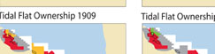
A second layer is the record of efforts to make San Francisco economically productive. These have continued into the present day, but we focus on two important and little understood episodes. The first are the commercial oyster beds that flourished in San Francisco Bay between the 1860s and the 1920s. By the 1930s the oyster beds had been sold to Ideal Cement, which mined the underwater beds for cement materials. Meanwhile, Leslie Salt Company between the 1930s and 1970s converted much of the marshy shoreline into evaporative salt ponds. Salt from these ponds supports chemical industries throughout the American West. Simplified if productive habitats, these ponds also support very dense populations of certain waterfowl. Some of the last parts of the bay to be converted to productive use, the salt ponds represent potential as well as past marsh habitat. They are the focus of one of the largest wetland restoration efforts in the United States.
Finally we seek to visualize the shifting trajectory of waste disposal in the region. If the bay and its cities have been sites of production and consumption, they have also created huge volumes of wastes. From mud and sand washed downstream by hydraulic miners in the nineteenth century, human and animal wastes dumped in by sewers, to the more recent dense concentration of solid waste dumps and toxic waste spills created by the high tech industry, the sediments and water of the bay is a precise record of the environmental consequences of industrial production and rising consumerism.
It is our hope that overlapping these layers of history will allow us to see and analyze patterns of environmental and cultural change in this particular space between the tides.