This website is no longer updated and has been replaced with a static copy. The Spatial History Project was active at Stanford University from 2007-2022, engaging in dozens of collaborative projects led by faculty, staff, graduate students, post-docs, visiting scholars and others at Stanford and beyond. More than 150 undergraduate students from more than a dozen disciplines contributed to these projects. In addition to a robust intellectual exchange built through these partnerships, research outputs included major monographs, edited volumes, journal articles, museum exhibitions, digital articles, robust websites, and dozens of lightweight interactive visualizations, mostly developed with Adobe Flash (now defunct). While most of those publications live on in other forms, the content exclusive to this website is preserved in good faith through this static version of the site. Flash-based content is partially available in emulated form using the Ruffle emulator.
Examples of Digitizing Rail from Historic USGS Quads

Authors: Killeen Hanson, Evgenia Shnayder, and Richard White
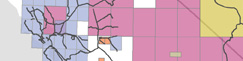
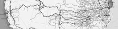
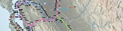
One of the goals of the Shaping the West project is to construct a complete digital and spatially accurate network of the railroads as they existed at the turn of the century. We scan the oldest available USGS topographic quadrangles at map archives and then digitally trace the scanned map image in ArcMap. These images illustrate a small sample of our railroad network superimposed on an original USGS quad.See it Fullscreen.
RELATED VISUALIZATIONS:
Quad Index

Seeing Space in Terms of Track Length and Cost of Shipping
California Railroad Commission,
Station Construction Data, 1850-1900
Station Construction Data, 1850-1900
The Expansion of the Western Railroad
Extent of Digitized Railroad
Railroad Repeats: The Alfred A. Hart Photo Project
RELATED PUBLICATIONS:

A Data Model for Spatial History