| |
047. |
|
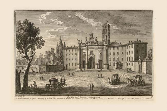
Basilica di S. Croce in Gerusalemme |
|
 |
|
 |
|
 |
|
| |
|
Basilica di S Croce in Gerusalemme |
| |
1. |
Acqedotto del acqua Claudia |
| |
2. |
Ruine del Tempio di Venere, e Cupidine |
| |
3. |
Parte del Monastero de Monaci Cisterciensi |
| |
4. |
Via che porta a S. Lorenzo |
At the left edge of this view of the Basilica of S. Croce in Gerusalemme, Vasi draws a series of arches which he calls the Claudian aqueduct (1). This would have to refer to a section of the aqueduct that had become part of the urban walls by the filling in of its arches under Emperor Aurelian (270-275). But the arches are shown as being open in the print, though on his map Nolli indicates that they were sealed (as they are to this day), revealing a possible error on Vasi's part. Another difference between Nolli and Vasi is the four-story structure to the left of the church facade: it does not appear in the map. This means that it was built between 1748 (date of the map) and 1753 (date of the print), to balance the similar structure to the right of the facade (3). Visible between the building and the aqueduct are the ruins of the Sessorianum (2), misnamed by both Vasi and Nolli, the palace of Helena, mother of the Emperor Constantine. She is credited with having brought back the True Cross from Jerusalem, a fragment of which was ensconced in this early church, whence its name (croce = cross). The curved facade of the church was built in 1744 by Passalacqua, and reflects the oval form of the large structure which that architect attached to the front of the medieval church (see Nolli for the plan). The gate at far right is the entrance into the monastery garden which Nolli shows to be oval in form since it occupied the interior of the Anfiteatro Castrense, a 2nd century amphitheater absorbed into the 3rd century Aurelian walls (NN 20). Behind the trees at the left edge of the print, Vasi indicates the road leading to Porta Maggiore and thence to S. Lorenzo outside the walls (4).
|
