| |
052. |
|
S. Maria in Dominica |
|
 |
|
 |
|
 |
|
| |
1. |
Chiesa di S Stefano Rotondo |
| |
2. |
Forme dell'Acqua Claudia |
| |
3. |
Villa Mattei |
| |
4. |
Chiesa S Maria in Dominica |
| |
5. |
Auanzi della Ch di S Tommaso in Formis |
| |
6. |
inscrizione antica |
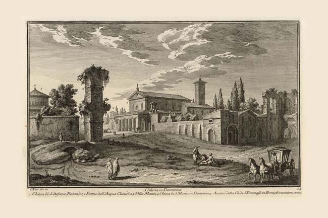
By taking a distant station point for his view of the 7th century church of S. Maria in Domnica (4), Vasi was able to include a number of buildings ranging from ancient aqueduct remains to a Renaissance villa. On the left is the circular early Christian church of S. Stefano Rotondo (1) dating from the 5th century. Immediately to the right is a dramatic fragment of the 1st century Neronian branch of the Claudian aqueduct (2), more of whose arches are visible at the right edge of the print. In the distance is the old entrance gate to Villa Mattei (3); now called Villa Celimontana, Plate 196, which was replaced in 1931 with the gate belonging to the demolished Villa Giustiniani on Via Merulana. The portico of S. Maria in Domnica was added at the time of the restoration of that church under Leo X (1513-21). Just visible to the right of the aqueduct fragment is the boat-shaped fountain of the Navicella (NN 943; navicella = small ship), which gives the name to the piazza in front of S. Maria in Domnica. When the Via della Navicella was widened in the 1930s, the fountain was moved so as to be on the axis of the church. What Vasi refers to as the remains of the church of S. Tomaso in Formis (5) ( Formis = aqueduct) was actually a medieval hospital attached to that still extant church (NN 941), whose entrance is approached through a gate beyond the arch at far left. The print shows the double-arched Romanesque portal of that hospital at the corner, which is all that remains of that structure today. The relationship of church and hospital is best seen on the Nolli map. The aqueduct at far right makes two right angle turns over the pre-existing arch of Dolabella with its ancient inscription (6), which is thought to be built on the site of one of the gates in the walls of the Republican city. The street through this arch, Via di S. Paolo della Croce, leads to the church of SS. Giovanni e Paolo, Plate 53.
|
