| |
095. |
|
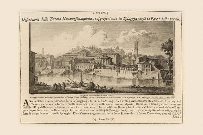
Spiaggia verso la Bocca della Verità |
|
 |
|
 |
|
 |
|
| |
1. |
Vestigy del Ponte Palatino |
| |
2. |
Palazzo detto di Pilato |
| |
3. |
Monte Palatino
|
| |
4. |
Ch di S Maria del Sole |
| |
5. |
Sbocco della Cloaca Massima |
| |
6. |
Ch di S Maria Cosmedin detta alla bocca della Verita |
In this view Vasi records the Renaissance neighborhood which developed in the area of the ancient Forum Boarium. Repeated demolition campaigns for the river walls in the late 19th century and for the Via del Mare in the 1930s have radically changed its appearance. At the far left Vasi notes the "Vestigij del Ponte Palatino" (1) referring to the remains of the missing section of Ponte Rotto, Plates 93, 94A. The floating mill and stairs are to be found in the Nolli map next to the dotted lines which represent that missing section of bridge. Above the stairs is the so-called House of Pilate (2) Plate 94. Soaring above and to the left of this house is the bell tower of the Palazzo Senatorio on the Capitoline hill. Moving to the right, the tops of the temple of Portunus (4) and the temple of Hercules, today isolated, appear as part of a dense urban neighborhood also featured in Plate 94. Between these two temples, against the Palatine hill (3) in the background, the triangular tympanum of the facade of S. Anastasia (NN 961) can be seen. The arch at the river level below the two temples is the mouth of the archaic Cloaca Maxima (5) the great storm sewer that drained the valley between the Capitoline, Quirinal and Palatine hills, enabling the Roman Forum to be built on the site of a former marsh. To the right of the temple of Portunus, the medieval church of S. Maria in Cosmedin (6) still sports its Baroque facade (stripped away in 1899). Another arch at river level to the right of the squarish building is the exit of the stream known as the Acqua Crabra which Nolli shows flowing through the farmland which occupied the Circus Maximus. In one of his rare lapses, Nolli mislabels the outlet for the Acqua Crabra as the Cloaca Maxima NN1088.
|
