Wide Area Differential GPS (WADGPS)
The Wide Area Differential GPS (WADGPS) Laboratory is a subgroup
of the GPS Laboratory at Stanford University and is closely
affiliated with the Local Area Augmentation
System Lab. Our research focuses on GPS navigation aids
for aviation in all phases of flight. We're located on campus,
in the Dept. of Aeronautics/Astronautics, so stop by Durand 452 for a visit.
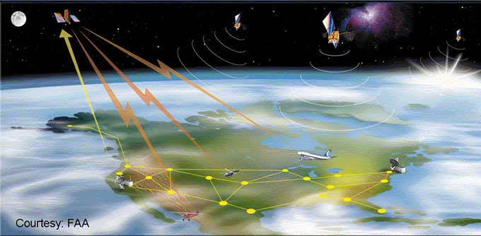
What is Wide Area Augmentation?
Late in 2003, the FAA will declare the Wide Area Augmentation
System (WAAS) operational. This system will monitor the GPS
constellation to provide differential corrections and, more
importantly, a certified level of integrity. The corrections
will improve the accuracy of the system from ten or more meters
to just one or two. It is the integrity, however, that will
open the doors for widespread aviation use. Although GPS does
have a strong track record, it has not yet been generally
approved for the most demanding of aviation applications.
GPS was not designed for these applications and lacks the
necessary real-time monitoring. Previously, aviation has had
to use RAIM, a technique exploiting redundant satellites,
to provide sufficient integrity. This technique requires good
geometry and wide margins. As such it is suitable for en route
flying and non-precision approach. However, precision approach,
which brings airplanes within a few hundred feet of the ground,
has more stringent needs. WAAS will enable aircraft to conduct
varying levels of precision approach. Additionally the instrumentation
required to use WAAS is substantially less expensive than
today's suite of equipment. Although WAAS is not yet certified,
there is an operational test signal that is available for
use and there already are several commercial WAAS capable
receivers. Because it incorporates nearly all the elements
of the final monitoring algorithms, this experimental signal
has a higher level of integrity than your typical differential
system. It is finding widespread use in agricultural and other
applications. More and more non-aviation users are discovering
the benefits of this free signal. It offers the great advantage
that the differential corrections come in the same antenna
that the GPS signals do. There are no additional antennas
to install, no local reference stations to set up, and no
additional communication channels to maintain. Just turn it
on and use it anywhere in the United States. Similar systems
are also being developed in Europe and Japan. Over time the
level of service is expected to improve. In 2003, the first
level of service, LNAV/VNAV, will be offered for aviation
instrument approach use. In later phases better availability
and lower decision heights will become possible.
Current Research Areas
Ionospheric Estimation
Signal Integrity and Availability
Antenna Design
Backup Navigation Systems
Evil Waveforms
Air Traffic Control Applications
Highlights
Juneau, AK flight testing (1-15 August 1998)
Creating the WAAS Correction Message
WAAS/NSTB Performance (triangle charts) (scripts available)
GPS Clock/SA anomaly
top
|