| |
091. |
|
Isola Tiberina verso Occidente |
|
 |
|
 |
|
 |
|
| |
1. |
Ghetto degli Ebrei |
| |
2. |
Ponte Fabrizio |
| |
3. |
Ponte Cesto |
| |
4. |
Mole de Grano |
| |
5. |
Muri dell' anticha Isola |
| |
6. |
Chiesa di S. Maria in Cosmedin |
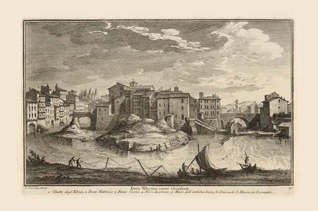
"Tiber Island toward the west" is a view looking downstream, taken from a point where the riverbank juts out into the Tiber. Both Vasi and Nolli actually show two islands, the left one (NN 1096) being little more than a sand bank which no longer exists because it was incorporated into the left bank of the river in the 19th century. Visible at the tip of the main island are the travertine blocks (5) which formed the bow of the "ship" into which it had been reshaped in antiquity. Part of the stern is still visible at the downstream end of the island. Since antiquity the island has been the site of a hospital, first in the form of the temple of Aesculapius (god of medicine) at the eastern end of the island. When the 10th century church of S. Bartolomeo all'Isola, Plate 92 was built over the temple, the hospital moved to the western end of the island where it is still active today as Ospedale Fatebenefratelli. Today the modern hospital (NN 1094) has replaced or absorbed all the buildings visible in Vasi's depiction of the island. The buildings on both sides of the two bridges which link the island to the mainland, have been demolished completely due to the construction of the river walls. On the north is the edge of Jewish Ghetto (1) Plates 29, 29A. All the buildings comprising it as seen in this view were completely demolished in the 1880s. The two ancient bridges, Ponte Fabricio (2) and Ponte Cestio (3) appear more clearly in the Vasi view, of the other end of the island, Plate 93. Above the latter Vasi shows the the distant S. Maria in Cosmedin (6) Plate 56. Rapids on both sides of the island made navigation difficult beyond this point (note the small arrow to the left indicating the direction of the current). This impediment necessitated two river ports, one for boats coming downstream from the north carrying mostly produce and wood (Porto di Ripetta, Plate 85) and one in Trastevere for larger boats coming up from the sea (Porto di Ripa Grande, Plate 97). Both Vasi and Nolli illustrate mole (wharves) and associated mulini (4) (grain mills) moored to the banks of the river and operated by its current.
|
