| |
|
 |
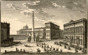 |
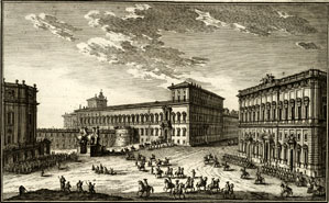
| Plate 61, Palazzo Pontificio sul Quirinale (without obelisk) |
Plate 61, Palazzo Pontificio sul Quirinale (without obelisk) |
Representing and Documenting the Evolution of Rome
By historical accident, Vasi and Nolli recorded the city at a time when it was at the zenith of its architectural and urban development. With the exception of the early 19th century redesign of Piazza del Popolo by Valadier one might argue that Romes most significant monuments and places from the post classical era were more intact then that at any later period (although archeological remains and some medieval structures have been made more visible today as a result of 19th and 20th century initiatives, extensive excavations have also exacted a toll on the citys urban fabric as it once existed as depicted by both Vasi and Nolli). Between Nollis 1748 map and Vasis last volume of the Magnificenze in 1761 the city remained virtually unchanged and so the two documents can be said, for all practical purposes, to cover an identical subject. The few exceptions of variance include the new piazza associated with the dependencies of the Palazzo Lancelloti, Plate 108, and portions of the Palazzo Corsini and its Gardens, Plates 72, 198. Similarly in the early editions of the Magnificenze Vasi shows a view of Piazza del Quirinale , Plate 61, without its obelisk, as it was placed there after his death in 1783-86. Later editions, reworked by his son Mariano, show the piazza with the obelisk.
With Rome becoming the capital of a unified Italy in 1870, radical change became more the norm in the historic center. The river embankments, excavations of the Roman and Imperial Fora, building of the train station as well as several other important urban interventions have changed the city from Vasis day. And yet this author counts that of the 238 views all but 20 sites are still recognizable today and that the overwhelming majority of views have all the principal features completely intact. What changes have occurred can be noted with the aid of satellite imaging. But its Vasis views, not Nollis map, that reveal the three dimensional change wrought in the city since the late 19th century. A plan view or satellite tells only one part of the story of change in Rome as the city increased its size vertically after 1870, some authorities suggesting that the city grew an average of two stories overall since then. Comparisons between Vasi and contemporary photographs make this clear. For example Piazza S. Appollinare, Plate 164, shows the adjacent Collegio Germanico with an added story. Meanwhile the Monte di Pietà has added an extra story since Vasis depiction of SS. Trinità, Plate 176 and there are other countless examples all of which can be verified with Vasis prints. |
