The Aerospace Robotics Laboratory conducts fundamental research in many different areas including autonomous navigation of space, air, land, and water vehicles, underwater stationkeeping and sea floor mapping, as well as problems for robots climbing in natural terrain. Our past research has included vehicular robotics, redundant and flexible manipulators, high-level sensing systems, human-robot interaction, and software development strategies.
Current Projects
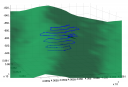
| Terrain Relative Navigation | A vehicle can estimate its position simply by measuring the shape of nearby terrain and comparing that measurement with a map. This concept is known as Terrain Relative Navigation (TRN). TRN is well suited to underwater vehicles. The ARL and Monterey Bay Aquarium Research Institute are interested in characterizing and extending the capabilities of TRN methods. |
 |
| Real-Time Mosaicking | Robotic exploration of remote environments often involves a video survey of scientifically-interesting sites. These video surveys are made challenging by the lack of reliable sensor data during remote exploration tasks, hampering robot navigation and hindering complete video coverage of a site. The real-time mosaicking project aims to aid remote video surveys by using a real-time navigation grade map (mosaic) of the survey area to correct unreliable sensor data and guarantee complete site coverage. |
 |
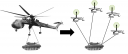
| Control of Heavy Lift Helicopter Teams | Aerial transportation of heavy loads into remote locations is traditionally done using large helicopters built for such a task. As the demand for heavier loads increases the obvious solution is to make larger helicopters. However, as the size goes up so does the cost and the complexity of the system. Alternatively, multiple existing helicopters can work cooperatively to achieve the same goal |
 |
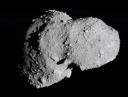
| Asteroid Navigation | To obtain a full geological, thermal and chemical profile of an asteroid requires science measurements to be taken from multiple locations. Ideally these measurements should be taken simultaneously. One approach suggested by the science community is to deploy multiple low cost multi-instrument measurement pods over the surface of the asteroid. The asteroid navigation project is exploring the engineering solutions required to locate these pods post deployment, and methods to navigate with respect to them. |
 |
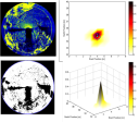
| Shadow-Based Robotic Localization | Shadows in sonar and visual imagery can be useful sources of information for the localization of mobile robotic systems. In the underwater domain, we have shown that acoustic shadows in sonar imagery may be correlated with topographical (bathymetric) terrain maps in order to provide an accurate terrain-relative position estimate. We have demonstrated this capability using data obtained from (1) a remotely-operated vehicle (ROV) equipped with a mechanically-scanned imaging sonar, and (2) an autonomous underwater vehicle (AUV) equipped with sidescan sonar. We are also developing estimation algorithms for the localization of a planetary rover using visual shadow information in descent imagery. |
 |