Local Area Augmentation System (LAAS)
What is Local Area Augmentation?
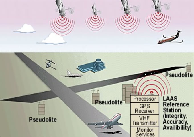
LAAS, or the Local Area Augmentation System, is the FAA version of the of the Ground Based Augmentation System, or GBAS, that
has been defined by the International Civil Aviation Organization (ICAO). LAAS is based on a single GPS reference station facility
located on the property of the airport being serviced. This facility has three or more (redundant) reference receivers
that independently measure GPS satellite pseudorange and carrier phase and generate differential carrier-smoothed-code corrections
that are eventually broadcast to user via a 31.5-kbps VHF data broadcast (in the 108 - 118 MHz band) that also includes
safety and approach-geometry information. This information allows users within 45 km of the LAAS ground station to perform
GPS-based position fixes with 0.5-meter (95%) accuracy and to perform all civil flight operations up to non-precision
approach. Aircraft landing at a LAAS-equipped airport will be able to perform precision approach operations up to at
least Category I weather minima. The pseudolites shown in the diagram below are optional means of improving user ranging
geometries with ground-based GPS-like transmitters but are not likely to be needed in the foreseeable future.
While computing and broadcasting differential GPS corrections is now straightforward, the largest challenge in designing
and fielding LAAS is the need to verify aircraft safety (in terms of not exceeding a safe error bound known as the alert
limit) to a probability of two in ten million (2e-7) per approach for Category I and one in one billion (1e-9) per approach
for Category III. In addition, the probability that approaches must be aborted due to detected failures or false alarms must
be below one in one hundred thousand (1e-5) per 15 seconds.
The LAAS Ground Facility, or LGF, meets these requirements by detecting and excluding anomalous reference receiver measurements
before differential corrections are broadcast. The corrections that are broadcast come with bounding standard-deviation values
("sigmas") on errors in the corrections that allow users to compute position error bounds (known as "protection
levels") in real time and to compare them to the alert limits for their current operation to verify that the operation
remains safe to conduct.
Stanford LAAS Research History
 For over a decade, Stanford University has been supported by the FAA Satellite Navigation Program Office (FAA AND-700)
to perform research on the system architectures, technologies, and algorithms needed for LAAS. Stanford's contributions began
in the early 1990's with the development and flight-test demonstration of the pseudolite and carrier-phase based Integrity Beacon
Landing System (IBLS) architecture which demonstrated that Category III automatic landings were possible using LAAS.
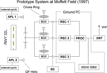
In the mid-1990's, Stanford developed and flight tested the "Intrack Airport Pseudolite (APL)" architecture
in which pseudolites were located at both ends of the runway to be serviced. This arrangement ensured that the pseudolites
could be sited within airport property, and it provided a significant vertical performance improvement at the end of
each approach, where it is needed most.
For over a decade, Stanford University has been supported by the FAA Satellite Navigation Program Office (FAA AND-700)
to perform research on the system architectures, technologies, and algorithms needed for LAAS. Stanford's contributions began
in the early 1990's with the development and flight-test demonstration of the pseudolite and carrier-phase based Integrity Beacon
Landing System (IBLS) architecture which demonstrated that Category III automatic landings were possible using LAAS.
In the mid-1990's, Stanford developed and flight tested the "Intrack Airport Pseudolite (APL)" architecture
in which pseudolites were located at both ends of the runway to be serviced. This arrangement ensured that the pseudolites
could be sited within airport property, and it provided a significant vertical performance improvement at the end of
each approach, where it is needed most.
Since 1998, the focus of Stanford research has been the development and testing of several generations of the Stanford
Integrity Monitor Testbed (IMT) prototype of the LAAS Ground Facility. The IMT includes all of the monitor algorithms and
logic needed to detect and isolate measurement failures before users are affected. Testing of the IMT under nominal and simulated-failure
conditions has demonstrated that its algorithms can meet the requirements of LAAS use for Category I precision approach.
Current Research Areas
The focus of current Stanford research on LAAS is in understanding the threats to LAAS user safety and optimizing detection and
mitigation methods for them. These threats include:
- Ionosphere Spatial Decorrelation (very sharp gradients in ionosphere delay that may occur during severe
ionosphere storms);
- Satellite Signal Deformation (anomalies in generation of ranging signal codes that create differential errors
between ground and user receivers);
- Large Satellite Ephemeris Errors (errors in the satellite locations reported in GPS navigation data
that are large enough to cause significant differential error between ground and user receivers);
- Satellite "Clock" Anomalies (anomalies in satellite frequency standards that create large apparent
deviations in pseudorange and carrier-phase measurements);
- Reference Receiver Anomalies (cycle slips, anomalous multipath, and other failure modes.)
 In
addition, Stanford research focuses on the logic required
to translate monitor detections into measurement exclusions
and fault diagnoses (collectively known as "Executive
Monitoring") and quantitative means to generate bounding
error sigmas for measurements that are not flagged as unhealthy.
Longer-term research is aimed at exploring applications of
LAAS beyond those than now exist as well as transforming the
existing single-frequency LAAS architecture into a more-robust
"end state" version that uses the future L5 (and
possibly L2) civil signals as well as the future Galileo satellite
constellation. Both L5 civil signals and Galileo satellites
should become available in numbers during the early part of
the next decade. In
addition, Stanford research focuses on the logic required
to translate monitor detections into measurement exclusions
and fault diagnoses (collectively known as "Executive
Monitoring") and quantitative means to generate bounding
error sigmas for measurements that are not flagged as unhealthy.
Longer-term research is aimed at exploring applications of
LAAS beyond those than now exist as well as transforming the
existing single-frequency LAAS architecture into a more-robust
"end state" version that uses the future L5 (and
possibly L2) civil signals as well as the future Galileo satellite
constellation. Both L5 civil signals and Galileo satellites
should become available in numbers during the early part of
the next decade.
Link to H. Konno 2006 Technical Note
top
|