| |
102. |
|
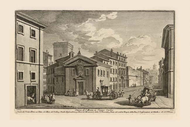
Chiesa di S. Maria in Campo Carleo |
|
 |
|
 |
|
 |
|
| |
|
Chiesa di S. Maria in Campo Carleo |
| |
1. |
Strada dei Conti |
| |
2. |
Torre nel Palaz. del Marc. del Grillo |
| |
3. |
Strada Alessandrina |
| |
4. |
Muri del Monasterio della SS. Nunziata |
| |
5. |
Ruine del celebre Tempio della Pace |
| |
6. |
Conservatorio de Zitelle e Ch. di S. Urbano |
Campo Carleo was another name for the area known as Pantano. This was a muddy, campo (open field) formed in the medieval period on the site of the Imperial Fora when the ancient storm sewer draining the runoff from the Quirinal hill became blocked, so that water stagnated in this area, (see Plates 53A, 142, 150A). In the 1560s Cardinal Michele Bonelli, nephew of Pius V Ghislieri (1566-1572), planned an extension of the city on this newly drained area with an irregular grid of streets, of which the main longitudinal thoroughfare was Via Alessandrina (3). We see this long, straight street framed by the Conservatorio and church of S. Urbano (6) leading to the Basilica of Maxentius (5) misnamed the Temple of Peace in Vasi's day, faintly visible in the distance with the bell tower of S. Francesca Romana (NN 72) Plate 32, rising above it. With the exception of the latter buildings and the Torre del Grillo (2) on the left, all of the buildings in this print were demolished in the early 1930s to make way for Mussolini's Via del Impero (now Via dei Fori Imperiali) linking Piazza Venezia, Plates 65, 39, to the Colosseum, Plate 33, and the concomitant excavation of the Imperial Fora. This pattern of urban disembowelment or "sventramento" as it was called, was part of a deliberate political program to clear away the older city fabric with its intricately woven streets and places and replace them with broad monumental streets and buildings that were intended to recall Rome's ancient splendor. Notwithstanding this urban devastation, the road bed of the Via Alessandrina survives to this day, entirely stripped of its flanking buildings. The street leading off to the left is called Strada dei Conti (1) by Vasi and Strada di Campo Carleo by Nolli, indicating the variability of street nomenclature in that period. The church of S. Maria in Campo Carleo (in the center foreground) dates back to the early medieval period, but was rebuilt in the Renaissance at a higher level only to be demolished in 1864. The blank wall further along the Via Alessandrina was part of the Dominican monastery of the Annunziata (4), which, with its church, occupied a full third of the Forum of Augustus.
|
