For the last month I had the opportunity to test the new iPad 3G as research tool under field conditions. The field site lies within the US, but some locations are remote (see below). For this particular project I was mainly interested in the use of the iPad as a location aware device. Below are some observations. You can skip directly to the summary.
GPS capability
Even before it came out, speculation about the iPad's GPS capabilities and chips began, and the discussion has continued ever since. Adding to the confusion is the fact that there is a Wi-Fi only iPad and a 3G model. Some claim that iPad 3G makes use of A-GPS, Apple's specifications simply state under Location: "Assisted GPS (Wi-Fi + 3G model)" and "Cellular (Wi-Fi + 3G model)", and a commenter confirms "Just returned from the Apple store where the salesman said the 3G iPad would NOT work without wi-fi or 3G connection." However, others found that iPad could in fact determine location out in the ocean without any access to internet or cell towers.
My own experience confirms the latter. One of our tours took us to a remote location on an island off the Georgia coast, without cell service and without wireless. I had preloaded Topomaps for the area and to my great surprise my iPad 3G was able to quite exactly - with an estimated 16ft error margin - pinpoint where I was. (The error margin estimation might be a bit optimistic. I looked up the lat/lon of the actual location where I was on Google Earth and compared it with the lat/lon values determined by iPad and found a distance of 43 ft between the two.) We happened to have both, iPhone 3G and an Android phone with us. Both were unable to determine their location in that area.
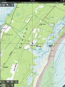
GPS location without Internet or cellular connection.
Note the "No service" on the top left.
Customized maps
Raster
Bit Map is an offline map viewer for your own topographic or specialized maps even when there is no phone or Wi-Fi network available. Bit Map can use map images from many common bit-mapped (raster) image file formats, including jpeg, png, tiff or gtiff. To make use of this application you will need to provide your own maps for use with Bit Map.
Using the Bit Map application I was able to upload a 370MB geotiff from David Rumsey's historical, digital map collection. The preparation of the file, however is not trivial, as it requires knowledge about map projection and extent. During upload the image is tiled and processed, which took my iPad around 10 min. However, Bit Map crashed, whenever I tried to zoom in too closely. The software has been updated since then, and the frequent crashing went away, but I was unable to do more tests in the field. There is a major change for a new version under development, which will require the pre-processing the map on a laptop or desktop to take this burden off the iPad/Phone RAM. If it works, it will allow to pinpoint (or track your location) on self generated raster maps.
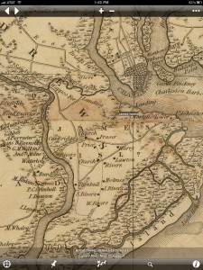
Robert Mills, Map of Charleston County, SC, 1825.
Way point added with the approximate location of James Island, west of Charleston, SC.
Vector
I also wanted to upload and take along shapefiles that I had digitized manually. I used the iPad Google Earth app for this, and the process I came up with at the time was the following:
1. convert .shp to .kml (for example, from the gdal library package run the command: ogr2ogr -f "KML" mymap.kml mymap.shp),
2. upload kml to MyMaps on Google,
3. under Layers > My Maps log into your account and point Google Earth app on iPad to the map.
Note that only one layer can be loaded like this at a time.
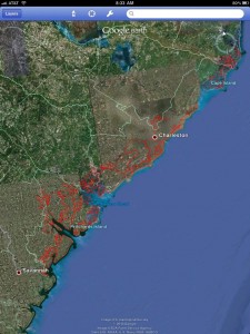
Island shapefiles overlaid on Google Earth as KML
In the mean time, ESRI came out with ArcGIS for iPhone/iPad. The name is somewhat misleading, as this application has nothing much to do with the real ArcGIS software from the same company. It is a viewer, which replicates some of the features that other iPad/iPhone mapping tools provide. It only has the most rudimentary analytic functionality so far, mainly the ability to measure distance and area. It draws upon the maps provided by ESRI through their new Arcgis.com service, as for example the world imagery, and by the contributing community. Another nice feature is the possibility to load additional maps provided through ESRI. It is not a large collection for now, and mostly US, but for example, I was able to map the median income of the area around me.
To use the iPad ArcGIS application for self generated maps, the best way at this point appears to directly connect to an ArcGIS server. Alternatively, you can sign up for a free account on http://www.arcgis.com/ and upload maps there. However, capabilities currently are severely limited. It is not possible to upload shapefiles directly. ArcGIS Online only supports ArcGIS map files (mxd, nmf, 3dd, sxd, ncfg, mpk, wmpk and pmf), ArcGIS layer files (lyr, lpk, and nmc), ArcGIS tools (eaz, and esriaddin), Map Templates (zip) and Desktop Application Templates (zip). In addition, only ArcGIS Server map, image, and feature services can be added to a map. Other layer types, such as layer packages, are not supported at this time.
Orientation and navigation
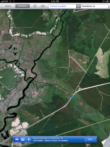
The built-in mapping application was sufficient (and very useful) for navigation. The exploration of historical landscapes is a particular research objective, and a real-time view from above of the area in which we were traveling was an important addition to contextualize the view on the ground, as for example the extensive area of abandoned rice fields northwest of the highway.
Recording in the field, geotagging
Despite reported issues with the stability of Evernote the application worked fine for my note taking on iPad during the field stay. I compiled mainly text notes, partly in the archive, partly at home and partly on the road. What was particularly interesting for me is that Evernote automatically geotags entries. However, those are currently not editable on iPad. This is fine for taking notes with the iPad on the road, but it is problematic for taking notes about a different location you are currently in. It is necessary to go back after the fact to the desktop client to edit the geolocation of those notes. My (Mac) desktop client does not have a map to drag a placemark, so it is necessary to first determine, then manually edit the lat/lon number values for each note.
One issue with any application that stores data on a company owned server is the storage of field data that require human subjects protection. IRB at Stanford tells me: "We have to evaluate these on a case-by-case basis, which means that they are probably fine for most projects". As alternative I experimented with Moe's Notepad. The interface is a bit discouraging, but storage is local and access to the notes can be password protected.
Tracking
In preparation for the field trip I experimented with Trails, a GPS tracker, which receives high marks from users and supposedly tops the tracking capabilities of the Garmin Edge 305 in wooded areas. Unfortunately it took me forever to find out how to record. (Go to Tracks > + > name the new track and save. A "Start recording" button will then appear at the bottom right.) In addition to the iPad's weight, the lack of multitasking poses an additional hurdle. So I ended up falling back to my Garmin device for tracking in the field. However, out of curiosity, I took a walk around the Oval with both a Garmin 60Csx and the iPad. I set both devices to log a point every 50m. No foliage, and they come out pretty even. I would love to know how the iPad chip can achieve such accuracy.
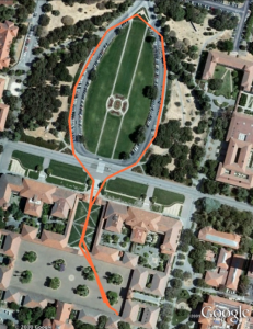 iPad Track |
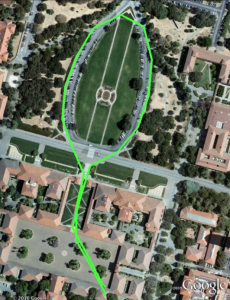 Garmin Track |
Summary
1. The astounding exactness of its GPS chip - at least within the US - makes iPad rival the Garmin.
2. Many of the applications I tried are intriguing and look promising. However, none of the ones I tested is really ready for prime time. At this point a set of tools may work for individual use cases and for certain needs. It is conceivable, though, that improvements in stability, the interface and the work flow can improve apps sufficiently to be used in a production environment. During the last five weeks of my exposure to iPad there was a constant flow of new and updated applications.
3. The sensitivity of stored data needs to be carefully considered when choosing an application or a work flow.
4. Reading the screen in bright sunlight is problematic.
5. Almost universal connectivity is very convenient.
GIS Applications used
Bitmap
ArcGIS app for iPad
Evernote
Google Earth
Moe's Notepad
Trails
Topomaps
Also used, but not discussed here
Dragon Dictation (to copy short quotes off documents)
Simplenote (for note taking)
Dropbox with Documents to Go (access and editing of spreasheets from both iPad and laptop)
IAnnnotatePDF (to comment on articles and imported student draft papers)
PDF reader (to import PDF from web/url)
Reeder (stellar RSS reader for use with Google Reader)
More pointers
iPad in education blog at at Vassar College
Discussion about iPad in research from the Association of Internet Researchers Listserv (several threads)
The Duke Project
iPad for Academics by Anthropologist Alex Golub, University of Hawaii at Manoa
CHE: More Universities Announce iPad Experiments